Appalachian Trail: Blackrock to Doyles River Overlook
Appalachian Trail: Blackrock to Doyles River Overlook
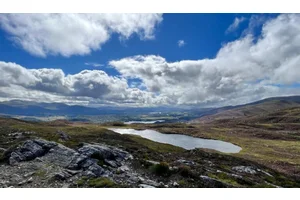
This quick 3.2-mile hike in Shenandoah National Park traverses the Blue Ridge to Doyles River Overlook, where views extend south across wooded slopes.
Heading out the door? Read this article on the new Outside+ app available now on iOS devices for members! Download the app.
Shelters: No shelters.
Trail Facts
- Distance: 5.1
Waypoints
WPT039
Location: 38.2285499572754, -78.7277145385742
SD 84.3
WPT040
Location: 38.2232513427734, -78.7333679199219
Blackrock parking
WPT036
Location: 38.2346000671387, -78.7173690795898
Dundo Gap Campground
WPT035
Location: 38.2402992248535, -78.7107696533203
Browns Gap; Browns Gap Rd.; SD 82.9
WPT034
Location: 38.2459678649902, -78.7053833007812
Big Run Loop Trail crossing
WPT032
Location: 38.2467002868652, -78.6939163208008
Doyles River parking. Overlook with views to the S. SD 81.9
WPT033
Location: 38.2458648681641, -78.6997299194336
SD 82.2
WPT011
Location: 38.2228317260742, -78.7333526611328
Blackrock trailhead
WPT038
Location: 38.2299995422363, -78.7259521484375
Jones Run trailhead. Trail to the E