Appalachian Trail: ME 15 to Jo-Mary Road
Appalachian Trail: ME 15 to Jo-Mary Road
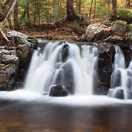
This classic 54-mile section travels through Maine's infamous 100-Mile Wilderness where countless notches, summit bids, and old-growth conifers are just a few highlights.
Heading out the door? Read this article on the new Outside+ app available now on iOS devices for members! Download the app.
Shelters: Leeman Brook Lean-to; sleeps 6. Wilson Valley Lean-to; sleeps 6. Long Pond Stream Lean-to; sleeps 8. Cloud Pond Lean-to; sleeps 6. Chairback Gap Lean-to; sleeps 6. Carl A. Newhall Lean-to; sleeps 6. Logan Brook Lean-to; sleeps 6. East Branch Lean-to; sleeps 8. Cooper Brook Falls Lean-to; sleeps 6.


Trail Facts
- Distance: 86.8
Waypoints
WPT023
Location: 45.400017, -69.466316
Canadian Pacific Railroad
WPT009
Location: 45.424801, -69.340614
Small stream
WPT004
Location: 45.413868, -69.399353
Trail to Barren Slide 250 feet (blue blaze)
WPT011
Location: 45.596058, -69.198959
Trail to Lean-to
WPT021
Location: 45.449665, -69.272652
Spring
WPT024
Location: 45.398983, -69.459747
Trail to Wilson Valley Lean-to and water
WPT009
Location: 45.479198, -69.288383
North Shore Pleasant River
WPT003
Location: 45.552551, -69.272415
Hay Mountain
WPT036
Location: 45.417667, -69.421303
Gravel road
WPT006
Location: 45.640178, -69.088018
Trail to shelter
WPT027
Location: 45.399765, -69.448051
Jeep road
WPT005
Location: 45.4132, -69.396667
Barren Ledges
WPT012
Location: 45.596851, -69.198303
East Branch Lean-to
WPT016
Location: 45.443668, -69.29583
Mudpit
WPT014
Location: 45.484336, -69.304942
Intersection of Gulf Hagas Trail and Pleasant River Road; Gulf Hagas Plaque
WPT011
Location: 45.430168, -69.331451
Fourth Mountain Bog
WPT009
Location: 45.561134, -69.234703
Logan Brook Lean-to; look for the waterfall water source that disappears under the rocky base
WPT001
Location: 45.616482, -69.126648
Sand Beach on Crawford Pond
WPT008
Location: 45.478966, -69.288452
West Branch Pleasant River requires you to ford across the 80 foot width here at the sandy banks; trail to parking
WPT016
Location: 45.530533, -69.314499
Trail to Alternate Tent site before finally crossing Gulf Hagas Brook
WPT009
Location: 45.351517, -69.498749
Leeman Brook Lean-to
WPT008
Location: 45.368584, -69.467117
James Brook
WPT022
Location: 45.39781, -69.469568
AT turns E; ford Big Wilson Steam
WPT014
Location: 45.596985, -69.193733
East Branch Pleasant River
WPT024
Location: 45.453152, -69.262466
Chairback Gap Lean-to 9769 Great campsites behind the shelter. Water source is steeply downhill.
WPT038
Location: 45.420666, -69.410934
Trail to Long Pond Stream Lean-to
WPT020
Location: 45.540535, -69.32003
Gulf Hagas Mtn.
WPT005
Location: 45.468067, -69.278168
Trail to East Chairback Pond .2 mi.
WPT009
Location: 45.644966, -69.079369
Stream
WPT025
Location: 45.398834, -69.459267
Wilson Valley Lean-to
WPT019
Location: 45.531033, -69.315117
Carl Newhall Memorial Lean-to
WPT004
Location: 45.340782, -69.523819
Bell Pond
WPT018
Location: 45.449417, -69.28627
Blue-blaze West Chairback Pond Trail to West Chairback Pond; stream 100 feet N
WPT003
Location: 45.456635, -69.255653
View N on bald; look into the valley where the AT makes a giant U-turn dipping down into the valley before heading back up the mountains in the opposite direction
WPT002
Location: 45.544899, -69.296333
West Peak
WPT001
Location: 45.453201, -69.262299
Chairback Gap Lean-to
WPT005
Location: 45.64035, -69.08746
Cooper Brook Falls Lean-to; waterfalls and good swimming immediately in front of shelter
WPT006
Location: 45.352901, -69.480499
Double track
WPT004
Location: 45.45665, -69.254051
Rock scramble down Chairback Mtn.
WPT004
Location: 45.556232, -69.263733
White Brook Trail
WPT006
Location: 45.554432, -69.246284
White Cap Mountain; Short side trail to the left leads to a great view of Katahdin
WPT005
Location: 45.556183, -69.2509
Blue-blaze to White Brook Road
WPT020
Location: 45.44965, -69.274567
Viewpoint
WPT022
Location: 45.449402, -69.270332
Columbus Mountain
WPT015
Location: 45.438583, -69.309303
Mudpit
WPT008
Location: 45.351383, -69.49868
Trail to Leeman Brook Lean-to
WPT010
Location: 45.579102, -69.224648
Gravel Road
ZZZ035
Location: 45.331215, -69.535934
AT continues straight across ME 15.
To access Monson, ME (the last major town on the AT that LOVES hikers), turn R for 4-mile jaunt into town. This small and friendly town is often packed with hikers, as it serves as the last major town for Northbound thru-hikers before Katahdin and 100-Mile Wilderness. Monson has a sign in the center of town indicating distances to Springer/Katahdin
WPT008
Location: 45.641865, -69.086487
Stream clear water
WPT011
Location: 45.373417, -69.471931
Little Wilson Falls
WPT009
Location: 45.363033, -69.471748
Mud Pond
WPT010
Location: 45.428101, -69.335648
Small stream
WPT004
Location: 45.351334, -69.484184
North Pond outlet stream
WPT012
Location: 45.375973, -69.468344
Rock furniture; unofficial campsite near Little Wilson stream
WPT003
Location: 45.62265, -69.12233
Old dam; pond outlet-Cooper Brook
WPT017
Location: 45.616516, -69.131119
Kokadjo-B Pond Road
WPT015
Location: 45.492867, -69.306686
Gulf Hagas Cut-off Trail
WPT014
Location: 45.378468, -69.470581
Small pond to the W
WPT015
Location: 45.607883, -69.173286
Mountain View Pond Outlet
WPT019
Location: 45.384949, -69.466469
Small stream
WPT018
Location: 45.616049, -69.127127
Trail to Sand Beach on Crawford Pond
WPT017
Location: 45.615391, -69.152626
Little Boardman Mountain
WPT012
Location: 45.484558, -69.304282
AT turns E @ jct. with Gulf Hagas Trail
WPT006
Location: 45.341499, -69.50843
Lily Pond
WPT003
Location: 45.352917, -69.488098
North Pond
WPT016
Location: 45.610283, -69.1689
Trail to spring
WPT020
Location: 45.393467, -69.466652
Thompson Brook
WPT006
Location: 45.473801, -69.29438
Logging Road
WPT034
Location: 45.419983, -69.431702
Wilbur Brook
WPT008
Location: 45.423882, -69.34343
Viewpoint
WPT006
Location: 45.420582, -69.354965
Trail to Cloud Pond Lean-to .4 mi.
WPT012
Location: 45.432499, -69.319435
Fourth Mountain; View to N of Third Mtn.
WPT002
Location: 45.453384, -69.262184
AT turns W on bog bridge; water
WPT017
Location: 45.444851, -69.293915
Monument Cliff
WPT013
Location: 45.483952, -69.304861
Screw Auger Falls
WPT007
Location: 45.415649, -69.370415
Barren Mountain Peak; old fire tower
WPT004
Location: 45.635418, -69.095901
Stream
WPT010
Location: 45.372749, -69.471298
double track
WPT039
Location: 45.420982, -69.410431
Long Pond Stream Lean-to
WPT037
Location: 45.417084, -69.419716
Long Pond Stream
WPT001
Location: 45.544617, -69.307083
Sidney Tappan Campsite
WPT035
Location: 45.420732, -69.428715
Vaughn Stream; waterfall
WPT010
Location: 45.652565, -69.04982
Stream
WPT014
Location: 45.437599, -69.309967
Small stream
WPT010
Location: 45.480568, -69.287933
Blue-blazed trail to Pugwash Pond and Hay Brook; Hay Brook Falls; parking
WPT007
Location: 45.351361, -69.498847
AT drops down a small gorge to Leeman Brook before scrambling back up to the trail to Leeman Brook Lean-to
WPT011
Location: 45.650898, -69.032005
Jo-Mary Rd.
DSCF9864
Location: 45.554439, -69.246247
DSCF9645
Location: 45.351346, -69.484121
DSCF9966
Location: 45.644451, -69.082901
DSCF9921
Location: 45.498653, -69.309258
DSCF9957
Location: 45.640732, -69.087616
DSCF9661
Location: 45.373699, -69.471832
DSCF9929
Location: 45.616484, -69.126604
DSCF9884
Location: 45.554434, -69.24618
DSCF9808
Location: 45.483954, -69.304821
DSCF9963
Location: 45.642166, -69.086365
DSCF9618
Location: 45.351354, -69.498739
DSCF9739
Location: 45.413265, -69.396797
DSCF9952
Location: 45.443943, -69.31279
DSCF9712
Location: 45.420732, -69.428675
DSCF9674
Location: 45.375851, -69.468697
DSCF9695
Location: 45.397975, -69.469578
DSCF9630
Location: 45.35115, -69.499179