Denali State Park: Little Coal Creek Trail
Denali State Park: Little Coal Creek Trail
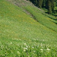
Nibble wild blueberries as you climb to dramatic views of 20,320-foot Mount McKinley on this easy, 4.3-mile out-and-back in the Talkeetna Range.
Heading out the door? Read this article on the new Outside+ app available now on iOS devices for members! Download the app.
Local secret: One of the best ways to sneak a peek at Mount McKinley—North America’s highest peak—is to trek into the Talkeetna Range in Denali State Park. Heed this advice and hike to breathtaking views of the Alaska Range on this easy, 4.3-mile out-and-back.
Begin with a gentle climb through a damp forest of ferns, white spruce, and birch. Roughly a mile into the hike, pass beneath a 4-foot beaver dam and climb the ridge (lined with blueberries) to the east. Remember: This is bear country, and you’re not the only mammal that appreciates these tasty trailside treats.
After a mile, the route climbs above treeline where low willow thickets and tundra reveal clear views to the west of 20,320-foot Mount McKinley, the Eldridge Glacier, and the braided Chulitna River below. More Alaska Range peaks and the Chulitna River valley stretch beyond the horizon to the north. To the east, the tundra-covered foothills of the Talkeetna Mountains rise to smaller snowy caps.
If it’s a clear day, linger, eat berries, take plenty of pictures, and count yourself lucky. The sight a 20,000-foot mountain rising above the river at about 1,000 feet is a shocking sight, and the mountain’s notoriously unpredictable weather can make unobstructed views of the summit and its surrounding knife-like peaks and interwoven snowfields elusive.
From here, the trail continues up the ridge for another 1.1 miles. At the turnaround point, savor more 360-degree views of the Alaska Range. Bring binoculars to zoom in on glaciers or to scour the Talkeetnas for bears and other wildlife. Follow the same route back to the trailhead.
-Mapped by Jenn Fields


Trail Facts
- Distance: 6.9
Waypoints
LCC001
Location: 62.891424, -149.7463989
Hike southwest from the Little Coal Creek Trailhead.
LCC002
Location: 62.8906993, -149.7480096
Stop and sign in at the trail register, then continue southwest toward Little Coal Creek. In 500 feet, the trail rounds to the east, paralleling the creek.
LCC003
Location: 62.8862473, -149.7262795
After a mile, the route climbs above treeline to the ridge ahead. Blueberry bushes line the trail (snack as you go).
LCC004
Location: 62.8858945, -149.7205219
As you gain the ridge, treat yourself to views of the Alaska Range across the valley. Mount McKinley is the high point, and the widest white ribbon snaking down its east side is the Eldridge Glacier.
LCC005
Location: 62.8857132, -149.7043419
Marshy area: Whack through willow thicket and mud for 100 yards or so. Don’t forget to yell “hey bear!” as you hike; you’re in prime bear country.
LCC006
Location: 62.8845396, -149.6996212
Drop your pack and enjoy 360-degree views of the Talkeetna Range behind you, and the Chulitna River and the Alaska Range to the west. Next, turn around and follow the same route back to the trailhead. Note: The trail continues from here but eventually fades into a bushwack.
Alaska Range
Location: 62.8845396, -149.699192
Little Coal Creek Trailhead
Location: 62.891424, -149.7458839
Lush Path
Location: 62.8893119, -149.7479439
Edible Watermelon Berries
Location: 62.8889208, -149.7396612
Beaver Pond
Location: 62.8880798, -149.7270012
Skirt the southern side of a beaver dam and pond.
Wild Blueberries
Location: 62.8866129, -149.7219372
Mount McKinley and the Chulitna River
Location: 62.8858501, -149.7201347
Mount McKinley and Alaska Range
Location: 62.8858697, -149.7197056
Above Treeline
Location: 62.8863782, -149.7145557
Talkeetna Foothills
Location: 62.8845788, -149.7028828
Overlooking Little Coal Creek in the Talkeetna foothills.
Talkeetna Range
Location: 62.884481, -149.6987629