Is the Lakeshore Trail the 40 Most Beautiful Miles In the Midwest? Hike it and Decide.
Is the Lakeshore Trail the 40 Most Beautiful Miles In the Midwest? Hike it and Decide.
The Lakeshore Trail offers 4 days of stunning views along Lake Superior.
Heading out the door? Read this article on the new Outside+ app available now on iOS devices for members! Download the app.
While the coasts and mountains of the United States are spectacular, it’s much more feasible and convenient for landlocked Midwesterners like me to just drive a few hours to get outdoors rather than flying across the country. When I asked a native Michigander who has completed the Pacific Crest Trail where I should go in his home state, he instantly recommended the Lakeshore Trail in Michigan’s Upper Peninsula. This easily accessible, moderate hike is an excellent way to transition into multi-day backpacking and to experience one of Michigan’s most popular tourist destinations from a different perspective.
Why You Should Hike Pictured Rocks National Lakeshore
The Lakeshore Trail, which is part of the 4,800-mile North Country Scenic Trail, covers the entire 42-mile section of Lake Superior’s coastline in Pictured Rocks National Lakeshore. This park has garnered fame for its colorful sandstone cliffs that water and time have shaped into caves, pillars, and other features. Most visitors choose to experience the park by boat, going on cruises run by local companies. Backpacking, however, helps you avoid most of the crowds. On my four-day hike this September, I ran into the occasional backpacker and dayhiker, but was generally able to enjoy the natural landscape in complete solitude and quiet.
My Trip Highlights
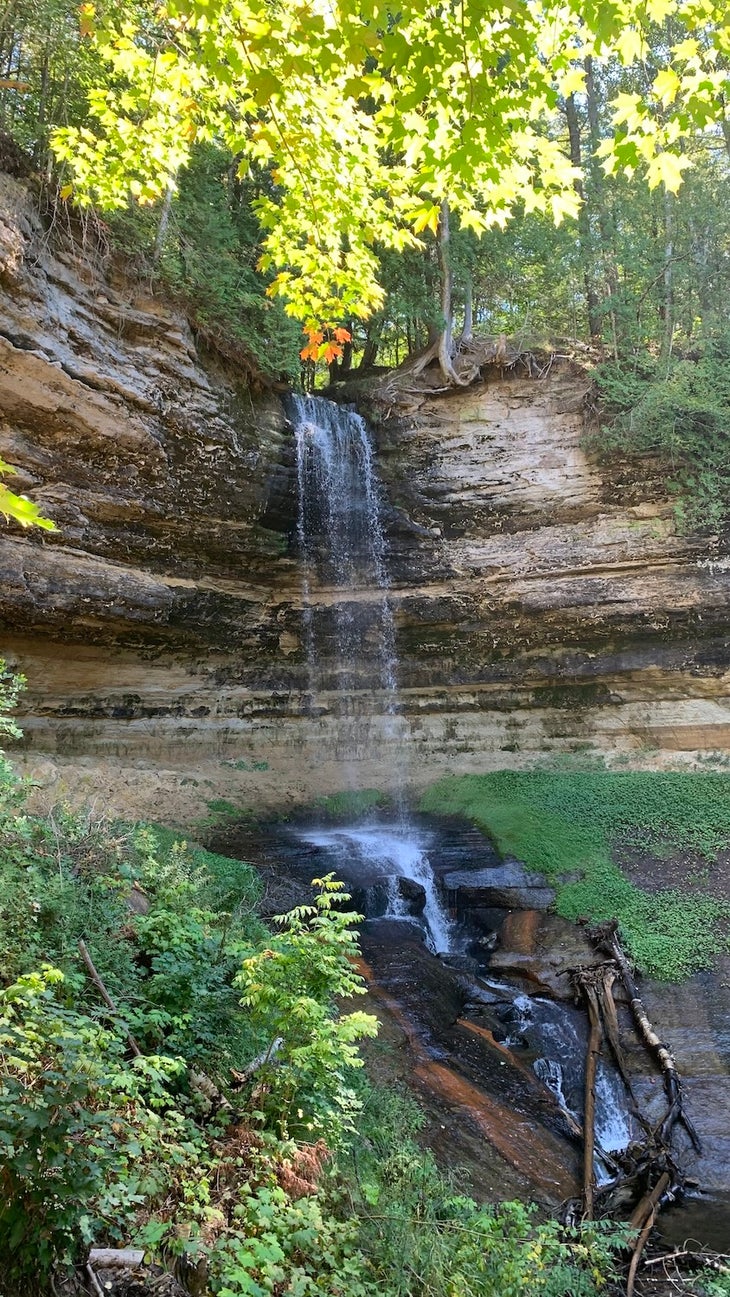
Every few miles along the trail is a historical marker or interesting rock formation; besides being visually engaging, they also help the miles fly by and feel less monotonous. There’s Chapel Rock, a tree-topped stone pillar that the lake carved into an arching, curving sculpture, and nearby is Spray Falls, a powerful, 70-foot waterfall that crashes into Lake Superior. Close to the eastern terminus of the trail, you’ll also find Au Sable Lighthouse, which was built in 1873 to protect ships passing by the infamous “shipwreck coast” of Lake Superior. Today, the lighthouse is open to the public and open to NPS-guided tours.
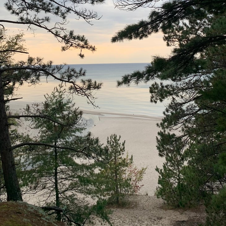
As you could have guessed from the name, Lake Superior is your constant and welcome companion along the Lakeshore Trail. As I hiked, I enjoyed continuous views of the water and the various cliffs along it. Each day, after I finished setting up camp, I swam for about an hour in the lake. It was the perfect way to soothe aching feet and tired muscles. Beaches at different campsites ranged from rocky to sandy, but I was comfortably able to swim barefoot each day. The lake is stunningly clear and almost a turquoise blue; if you showed me pictures of the lake and said it was in the Caribbean, I’d believe you. There was something special about unzipping my tent in the morning and watching the sun come up and shine on the water as I sipped my coffee, especially in my east-facing Beaver Creek campsite.
Lakeshore Trail Basic Information:
- Length: 42.4 miles. It took me four days to complete the trail, but it is easily possible to finish it in three.
- Location: The trail’s eastern terminus is Grand Sable Visitor Center and the western is Munising Falls Visitor Center. Hiking westbound means that you save the most beautiful and scenic parts of the hike for the end. The small town of Munising is less than 2 miles from Munising Falls Visitor Center and offers gas, food, services, etc.
- Best Time to Hike: September to October or April to May. (Avoid the summer, which is peak stable fly season.) I completed the trail in mid-September, so I experienced temperatures in the mid-70s during the day, very little rain, and gorgeous fall foliage.
- Wildlife: Black bears are present in the park; each backcountry campsite has a food storage locker. Using them also helps prevent chipmunks and other critters from getting into your food and smellables.
Permits
The NPS requires a backcountry permit year-round for any overnight camping at Pictured Rocks National Lakeshore. On the permit, you must specify which campground and campsite you will stay at each night. The park charges a $15 reservation fee, and then a $5 user fee per person, per night. Backpackers can purchase permits here. You can also print your permit as early as 14 days before the trip start date. Once you print your permit, it is final and you have to camp in the campsites you’ve reserved. I booked my September permit in June without a problem. With just a bit of foresight, hikers should easily be able to secure a permit for their selected dates.
Transport
Alger County Transit (Altran) runs a shuttle service that drops off hikers at either terminus. I parked my car at Munising Falls, caught the shuttle there to Grand Sable, and then hiked back toward my vehicle. Rides cost $35 per person and can be purchased here.
Bugs & Insects
Pictured Rocks National Lakeshore does have one glaring drawback: the stable flies. The peak season for these pesky blood feeders is June through August, but I still saw plenty in mid-September. Not only can the stable fly bite through clothing (they bit through my thick wool socks), but also insect repellent is ineffective against them. The flies tend to be worse close to the water and on humid, non-windy days.
On my hike, the flies were rather awful for the first 10 miles; as soon as I stopped walking, they swarmed. Thankfully, they were only a mild nuisance after that. This could be because the wind direction changed, which makes a big difference, or because the final 30 miles of the trail had less decaying vegetation where flies live and lay eggs. Stable flies are not known to transfer diseases to humans, but their bites can be painful and itchy. Also, although the NPS does warn hikers about mosquitos and ticks at Pictured Rocks, I didn’t encounter either. However, as always, bring insect repellent and be sure to check yourself for ticks periodically.
Trail Conditions
The Lakeshore Trail was extremely well marked, with signposts at almost every intersection or turnoff. You would really have to try to get lost on this trail. Of course, you should always carry a map. Both visitor centers sell the Classic Trails of Michigan: Pictured Rocks Lakeshore map. The trail is also very well maintained; the NPS removes fallen trees and other obstacles from the trail regularly. Also, most water crossings and boggy, muddy parts of the trail are covered with bridges or wood planks.
Campsites
There are campsites approximately every 2 to 3 miles on the trail. Certain sites are accessible from the road and open to the general public (such as Hurricane River and Twelvemile Beach). If you’re looking for peace and quiet and to get away from the rest of the world, I recommend staying at backcountry-only sites. Most sites are extremely close to Lake Superior and thus have ample access to water, the two exceptions being Potato Patch and Cliffs. All sites except Mosquito River and Chapel Beach have a group firepit and allow campfires.
My itinerary was the following (east to west): Benchmark (mile 11.2), Beaver Creek (mile 20.4), and Mosquito River (mile 30.4). Ironically, given the name, Mosquito River was the site with the least amount of bugs on the entire trip. All three sites were perched slightly above the lakeshore, providing protection from the stable flies and many opportunities to watch sunrises and sunsets along the water.
How Hard is the Lakeshore Trail?
The Lakeshore Trail is a moderate trail, with approximately 2,000 feet of elevation gain across its 42 miles. The trail has the occasional steep but brief ascent or descent (without switchbacks). Gently rolling changes in elevation are common. The most physically demanding aspect of the trail comes from its terrain; throughout the trail, there are several sections of loose, dense sand. Hiking through the sand with a substantial pack definitely got my legs burning and my heart pumping. That being said, any hiker with solid baseline fitness and some outdoor experience should be able to complete the trail.
For more information, visit the national lakeshore’s website.
From 2024