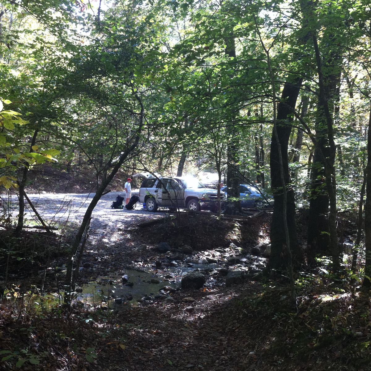
Mena, AR: Buckeye Mountain To Caney Creek Loop
Mena, AR: Buckeye Mountain To Caney Creek Loop
Slicing through the southwest reaches of Arkansas’ picturesque ridge country, this 10-mile loop climbs to Buckeye Mountain before tracing the meandering Caney Creek.
Heading out the door? Read this article on the new Outside+ app available now on iOS devices for members! Download the app.
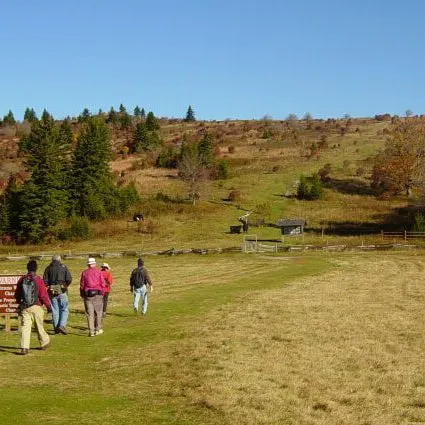
From the east Caney Creek trailhead, fill up water bottles at Blaylock Creek (the only water source until Katy Falls at mile 5.6) and head north on the trail paralleling Forest Road 42. At mile 1.1, pick up the Buckeye Trail and head west toward Buckeye Mountain (2,254 feet), the route’s highest point. Enjoy far-ranging panoramas of the tree-topped countryside from Buckeye’s summit before heading west along the ridgeline connecting to East Hanna Mountain. You’ll snag various hilltop vistas before the route bends south and dips downhill at mile 4.6.
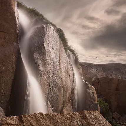
Fill up on water at the tranquil Katy Falls, which owes its lucid appearance to minerals in the Arkansas Novaculite rock abundant in the area. Immediately following the falls, you’ll hit the junction with the Caney Creek Trail. Turning right brings you to campsites (0.1 mile west), while the left fork traces Caney Creek back to the parking lot you started from (3.9 miles). Heading east on the hike’s home stretch, you’ll pass another campsite and numerous creek crossings, some of which may prove to be wet when water levels are high. The hike ends with a quick crossing of Blaylock Creek before breaking out of the Buckeye Wilderness and into the parking area.
-Mapped by Tommy Smith


Trail Facts
- Distance: 16.0
Waypoints
BCL001
Location: 34.39688, -94.022723
Leave your car in the lot at Caney Creek trailhead (off Forest Road 38) and head north for 1.1 miles to the Buckeye trailhead. Fill up water here: next source is 5.6 miles away at Katy Falls.
BCL002
Location: 34.408786, -94.028335
Turn left at the Buckeye trailhead.
BCL003
Location: 34.40517, -94.0303
This large standing rock, composed of the Arkansas Novaculite which is prevalent in the area, makes a good break spot.
BCL004
Location: 34.40583, -94.034729
Climb Buckeye Mountain for superb views of the surrounding countryside. Stay straight on the Buckeye Trail to bypass the many side trails here.
BCL005
Location: 34.405883, -94.036682
From Buckeye Mountain’s summit, head west along a ridgeline stretching to East Hanna Mountain.
BCL006
Location: 34.407172, -94.076091
At mile 4.7, begin heading down the southeast contours of East Hanna Mountain. At the upcoming junction, you’ll bear right to continue your descent. Katy Falls Spur, which offer a chance to fill up water bottles, is one mile down the trail.
BCL007
Location: 34.396995, -94.080863
Take the spur trail (marked with a crude cairn) to Katy Falls to fill up on water. The trail, which follows Katy Falls back to the trailhead, provides numerous water sources for the remainder of the trip.
BCL008
Location: 34.395333, -94.0815
The Buckeye Trail ends at the junction with the Caney Creek Trail. Developed campsites lie 0.1 mile to the right, while turning left leads back to the Caney Creek trailhead (3.9 miles).
BCL009
Location: 34.396145, -94.084854
Water is available at the developed campsites next to Caney Creek.
BCL010
Location: 34.395402, -94.051251
Prepare for a potentially wet Caney Creek crossing at mile 7.7.
BCL011
Location: 34.397278, -94.037304
Break spot along Caney Creek: trailhead is one mile to the east.
BCL012
Location: 34.39686, -94.0229
Mission accomplished: return to the parking lot and trailhead upon breaking out of the Buckeye Wilderness.
Trailhead
Location: 34.396729, -94.022605
Water is available from the creek at the trailhead, and the parking lot is large enough to hold around six cars.
Buckeye Trailhead
Location: 34.408804, -94.028308
At mile 1.1, pick up the Buckeye Trail and head west.
Arkansas Novaculite
Location: 34.405175, -94.030695
Arkansas Novaculite, a light-colored sedimentary rock, is prevalent throughout the region. Minerals in the rock help water in creeks and rivers appear extremely clear.
Buckeye Mountain
Location: 34.405757, -94.035138
Notch superb vistas of the surrounding countryside from Buckeye Mountain (2,254 feet).
Ridgeline Panoramas
Location: 34.406449, -94.059362
Enjoy extended panoramas of the tree-blanketed countryside while traversing the ridge between Buckeye Mountain and East Hanna Mountain.
Descent
Location: 34.406667, -94.076333
Dip into the Caneye Valley from the southeastern face of East Hanna Mountain.
Katy Falls
Location: 34.396943, -94.080336
Katy Falls provides the first water source since the trailhead.
Campsite
Location: 34.396335, -94.084863
Water is available at these developed campsites situated next to Caney Creek.
Caney Creek Trail
Location: 34.395578, -94.062149
Trace the Caney Creek as you head east to the trailhead.
Caney Creek Crossing
Location: 34.395366, -94.051037
After heavy rain, you’ll have to negotiate with a potentially wet crossing here.
Caney Creek
Location: 34.397274, -94.037298
You’ll cross the Caney Creek on numerous occasions during your eastward trek back to the trailhead.
Back To Reality
Location: 34.39688, -94.022992
Break through the Buckey Wilderness border and back to the real world upon hitting the eastern Caney Creek trailhead.