Portland, OR: Munra Point
Portland, OR: Munra Point
One of the Gorge's steepest and most enjoyable trails, the path to Munra Point features several challenging scrambles and five-star views across the Columbia River.
Heading out the door? Read this article on the new Outside+ app available now on iOS devices for members! Download the app.
Save this challenging hike for a dry day—and prepare to climb nearly 2,000 feet of elevation in 2.5 miles. From the trailhead, head southwest through open woods and immediately cross Tanner Creek on a wide, paved bridge. After 1,000 feet, turn left onto the Gorge Trail for a brief climb up the Tanner Creek drainage and an easy-going traverse of Munra Point’s lush northern slopes. At mile 1.6, turn left at the signed junction for the final, 0.9-mile push to Munra Point. Pace yourself—this unmaintained path gains more than 1,600 feet of elevation and requires some tricky scrambling. After 2.4 miles, crest Munra Point’s moss-covered summit and savor spectacular views across the Gorge. Follow the same route back to the trailhead.
-Mapped by Galen Williams


Trail Facts
- Distance: 3.9
- Miles from city center: 39
Waypoints
MUN001
Location: 45.630489, -121.9536871
From the Wahclella Falls parking area, head south for 100 feet, then turn right and head north for 400 feet to reach the trailhead.
MUN002
Location: 45.6313556, -121.9539553
At the trailhead, head southwest on the paved trail (marked with a “Moffett Creek to Tanner Creek Section” sign).
MUN003
Location: 45.631273, -121.9542503
Walk across the wide, paved bridge over Tanner Creek, a cascading creek bordered by lush, open woods. Continue following the paved road.
MUN004
Location: 45.6307929, -121.955519
Turn left off of the paved road onto Gorge Trail (No. 400). Ahead, the trail starts to climb up the Tanner Creek drainage.
MUN005
Location: 45.6294049, -121.9549638
The trail switchbacks to the right and heads north.
MUN006
Location: 45.630988, -121.9576728
The trail leaves the Tanner Creek drainage and traverses the lush northern slopes of Munra Point, heading southwest.
MUN007
Location: 45.623395, -121.975692
Turn left (south) onto the trail to Munra Point @ 3-way junction. This junction is marked with a “Trail Not Maintained” sign (the word Munra is etched into the sign). The stiff ascent to Munra Point starts here: You’ll gain more than 1,600 feet of elevation in the next 0.9 mile.
MUN008
Location: 45.6230011, -121.9717437
Keep your camera handy: Along this scenic stretch of trail, you’ll be treated to bird’s-eye views of the Columbia River Gorge.
MUN009
Location: 45.6228322, -121.9706869
Tackle one of several steep scrambles that require the use of both hands. You’ll have to climb an 8- to 10-foot-high rock outcropping to continue on the trail.
MUN010
Location: 45.6227272, -121.9636917
At this point, the trail looks impassable due to a large, moss-covered rock face. Bypass this rock wall by hiking through some bushes on the left (north) side of the face.
MUN011
Location: 45.6225809, -121.9619536
Use caution while maneuvering up the 50-foot slot that rises 150 feet west of Munra Point. Note: This scramble is not recommended in wet weather.
MUN012
Location: 45.6226446, -121.9614601
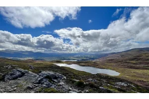
Munra Point (1,814 ft.): On clear days, this rock pinnacle offers spectacular views across the Gorge. Follow the same route back to the trailhead.
Gorge View
Location: 45.6229973, -121.9716847
©Galen Williams
Wahclella Parking
Location: 45.6304853, -121.9536388
Sign for the Wahclella Falls parking area. ©Galen Williams
Trailhead Sign
Location: 45.6313556, -121.9539338
Pass the trailhead sign just before crossing Tanner Creek. ©Galen Williams
Bridge
Location: 45.6312768, -121.9542235
Bridge over Tanner Creek. ©Galen Williams
Tanner Creek
Location: 45.6312393, -121.9543791
Views of Tanner Creek near the bridge. ©Galen Williams
Views from Gorge Trail
Location: 45.6304253, -121.9609612
©Galen Williams
Munra Point Trail
Location: 45.623395, -121.97559
©Galen Williams
Forest
Location: 45.6228923, -121.973691
View of the lush underbrush in this area of the forest. ©Galen Williams
View South
Location: 45.6227047, -121.9715399
View looking south into the Cascades. ©Galen Williams
Short Climb
Location: 45.6228397, -121.9706225
Hikers must climb a rock outcropping to continue on the trail. ©Galen Williams
Gorge Views
Location: 45.6230348, -121.970129
Another vantage point looking west into the Gorge. ©Galen Williams
Topslot
Location: 45.6225771, -121.9619
©Galen Williams
Munra Point
Location: 45.6226409, -121.9614065
The top of Munra Point. ©Galen Williams