Santa Fe, NM: Alamo to Capulin Canyon Loop
Santa Fe, NM: Alamo to Capulin Canyon Loop
Climb across mesas and up canyon walls to a cave full of pictographs.
Heading out the door? Read this article on the new Outside+ app available now on iOS devices for members! Download the app.
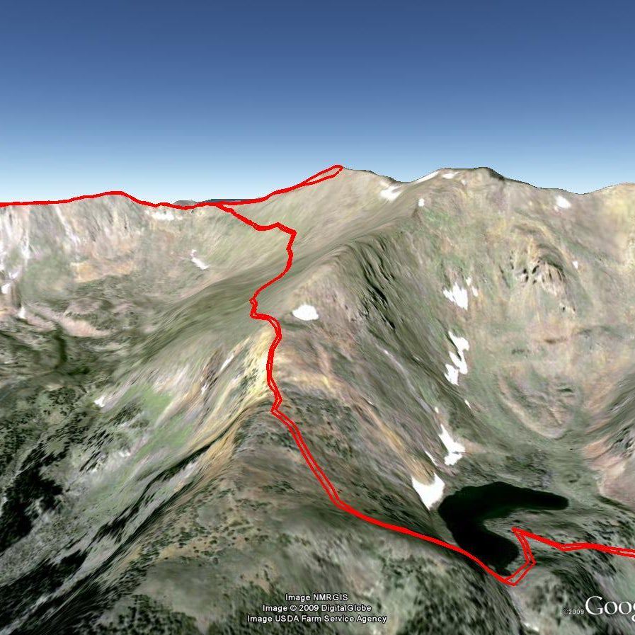
Find rarely visited ruins hidden in New Mexico’s big-sky desertscape on this difficult, 20.4-mile trek. Leave Monument Headquarters heading northwest to the Frijoles Canyon trailhead and follow the dirt path up 100 feet to a right turn at a T-junction. At the mesa top, look right across Frijoles Canyon’s pinkish cliffs of tuff, a soft rock formed from volcanic ash. Go right at the T-junction, then left at a Y-junction 200 feet later, and for the next 2.2 miles, weave through piñon, junipers, and sagebrush on Pajarito Plateau. Look for prickly pears, cane cholla, and yucca.
Cross Lummis Canyon, a pocket oasis full of aspens. Reach Alamo Canyon. The views from the rim of this 500-foot-deep trough are some of this trip’s finest. Go right at the next Y-junction toward Yapashi Pueblo. In .6 mile, oblong boulders rest in a 650-foot-diameter circle, the remains of the Cochiti Puebloans’ 385-room village. Walk .5 mile, then bear left toward Capulin Canyon. This loop’s only reliable water source irrigates the interior. Camp in Zone D on a bank a few feet above the creek (in dry years, camp at an up-canyon site).
Next day, tank up with one gallon per person and follow cairns south. In two miles, head east across a dry tributary on the .1-mile spur to Painted Cave. Continue south to reach a sandy trail at the canyon’s end and turn left. Pass a patch of Dali-esque spires on the mesa, then head north up a sandy path along the western wall of Hondo Canyon. Switchback into the canyon and head across the wash.
At the Hondo Canyon sign, follow cairns on a loose-rock path up the canyon’s eastern wall. Bear left at the Y-junction, and after a half mile, look right to see the muddy Rio Grande. Follow cairns for three view-packed miles to a rocky wash. From here, continue .2 mile to close the Capulin Canyon loop, then return to the headquarters.
GEAR UP CB Fox Department Store, 1735 Central Ave., Los Alamos. (505) 662-2864
SEASON Spring for mild weather and the greatest variety of wildflowers
INFO (505) 672-3861
MAP Bandelier National Monument ($12, natgeomaps.com)
-Mapped by MacKenzie Ryan
Trail Facts
- Distance: 32.9
Waypoints
BNM001
Location: 35.779033, -106.270736
Visitor Center
BNM002
Location: 35.779035, -106.272376
Trailhead to Painted Cave
BNM003
Location: 35.778889, -106.272576
Take a right at the T-junction.
BNM004
Location: 35.782303, -106.276333
Turn left here and follow the trail northwest.
BNM005
Location: 35.782945, -106.278779
Look for views of cliff dwellings from this spot along the trail.
BNM006
Location: 35.785747, -106.286522
Go right at the T junction.
BNM007
Location: 35.78624, -106.287012
Bear left at the Y-junction 200 feet later, and head toward Mid Alamo and Yapashi. For the next 2.2 miles, hike through junipers and sagebrush on Pajarito Plateau.
BNM008
Location: 35.769818, -106.301895
The trail winds south into Alamo Canyon.
BNM009
Location: 35.765757, -106.302272
Arrive at an overlook: the views from here are some of the trip’s finest.
BNM010
Location: 35.766258, -106.302979
Alamo Canyon: No Camping Zone
BNM011
Location: 35.762881, -106.301243
Hang a left here to stay on the trail.
BNM012
Location: 35.762637, -106.3009
Bear right and cross drainage.
BNM013
Location: 35.758472, -106.299751
Crest the top of the canyon.
BNM014
Location: 35.757655, -106.305513
Take a left turn.
BNM015
Location: 35.75764, -106.305567
Continue straight at the four-way junction.
BNM016
Location: 35.758071, -106.307858
Bear right at this 3-way, and hike northwest toward the Yapashi Pueblo.
BNM017
Location: 35.761442, -106.315597
Arrive at Yapashi Pueblo, where oblong boulders rest in a 650-foot-diameter circle. Continue .5 mile.
BNM018
Location: 35.763062, -106.31843
Cochiti Lake
BNM019
Location: 35.765507, -106.321829
Bear left toward Capulin Canyon.
BNM020
Location: 35.754896, -106.325831
Camp in zone D, to the left, on a bank a few feet above the creek.
BNM021
Location: 35.754035, -106.325543
Cross a small stream and continue hiking south.
BNM022
Location: 35.746164, -106.326714
Camping Zone D, continue 1.2 miles south to next creek crossing.
BNM023
Location: 35.730465, -106.323457
This stream crossing may be a dry wash during parts of the year.
BNM024
Location: 35.727786, -106.323502
Entering a “No Camping Zone”.
BNM025
Location: 35.725245, -106.322765
Cross another small stream.
BNM026
Location: 35.721709, -106.321392
Head east across a dry creek on the .1 mile spur to Painted Cave.
BNM027
Location: 35.722197, -106.320019
Reach Painted Cave, 50 feet about the foot trail and painted with red mineral markings across its mouth.
BNM028
Location: 35.713643, -106.312509
Here, turn right.
BNM029
Location: 35.707589, -106.301451
Potential Campsite
BNM030
Location: 35.707972, -106.30068
Bear left to head north up the canyon.
BNM031
Location: 35.710342, -106.301037
Switchback into Hondo Canyon and head across the wash. Follow cairns up the eastern wall.
BNM032
Location: 35.709948, -106.297862
Go left at the Y-junction and continue for .5 mile.
BNM033
Location: 35.712301, -106.297789
Cross wash and continue north.
BNM034
Location: 35.716389, -106.29663
Look right to see the Rio Grande.
BNM035
Location: 35.755604, -106.309005
After three rocky miles, cross a rocky wash. Ahead: The route reconnects with Waypoint 16. Turn right and retrace your steps back to the trailhead.