I’ve Lived in Santa Barbara My Whole Life. Here Are My 4 Favorite Hikes.
I’ve Lived in Santa Barbara My Whole Life. Here Are My 4 Favorite Hikes.
Escape the beach-bound tourists on a local's favorite trails.
Heading out the door? Read this article on the new Outside+ app available now on iOS devices for members! Download the app.
There’s something to be said about the sheer resilience of the Santa Ynez Mountains, the mountain range behind Santa Barbara, California. Countless wildfires have burned these slopes and their foothills, affecting many Santa Barbara hikes and natural spaces, as recent as the Lake Fire that burned through the Los Padres National Forest for a full month this summer. (The trails below are all currently open, unaffected by the recent fires.)
This area is fertile and primed for regrowth. On some trails, burnt chaparral stands out amidst the sprawling foliage. The ease with which Santa Barbara’s flora and fauna recovers is a testament to the fecund ecosystem despite all the wildfires.
To see the complete beauty and endurance of Santa Barbara’s native plants and animals, you have to leave the safety of your beach chair and hit the trails. I grew up hiking here. The landscapes—from coastal bluffs overlooking the Pacific Ocean to lush mountains teeming with diverse plant life—will never grow old.
The trails below are in Santa Barbara and the surrounding area. While hiking here, or anywhere for that matter, respect the land and the people surrounding it. Don’t park in undesignated areas, make sure to pick up your dog’s poop, and never leave trash on the trails.
Rattlesnake Canyon
Rattlesnake Canyon happens to be my dad’s and my favorite hike in town. It’s the perfect trail for your furry friend on a hot day, as surrounding oak trees provide shade, and various ponds offer natural spaces to take breaks to cool off. You’ll want to keep them on a leash for your safety and theirs.
The entrance to this hike is next to the narrow bridge on Las Canoas Road. You’ll know you’re in the right place when you spot a sign that reads, “Skofield Park, Rattlesnake Canyon Wilderness Area.” Despite the hike’s daunting name, you’ll only have to be on the lookout for rattlesnakes in the summer.
It’s a relatively challenging trail that crosses multiple streams, so be wary of your footing. Trees cover most of the trail, leaving some open parts at the beginning. Once I reach Tin Can Meadow, I usually take a break, then turn around to hike back to the trailhead, which ends up being about 4.5 miles total. If you want to keep going, you can extend your hike by following the trail across the field and then going left, which takes you to the Tunnel Connector Trail for an 8.2-mile roundtrip hike.
Upper Outlaw Trail, Arroyo Hondo Preserve
Although Arroyo Hondo Preserve is about 20 minutes from Santa Barbara, it’s worth the short drive to visit the beautiful landscape. The preserve is 782 acres protected by The Land Trust for Santa Barbara County. The property harbors many trails and is only open on the first and third weekends of each month; reservations are required, and no dogs are allowed.
My dad, sister, and I visited the Preserve for the first time this Father’s Day. After parking our car in the lot, we went to the historic wooden building turned into a makeshift visitor’s center. Here, volunteers provided maps and other information about the trails and the history of the land. From there, we made our way to the gate at the beginning of the trail, past the sign that reads “Arroyo Hondo Preserve,” through the meadow, and then across a creek.
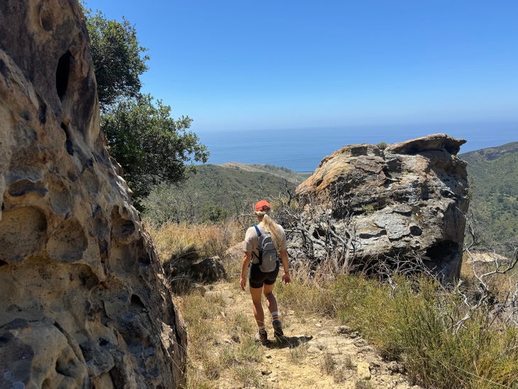
After crossing the creek, we veered right and took the Upper Outlaw Trail, which is a steep climb with limited tree cover. It ended up being about 4.2 miles. (If you want something easier, take the Lower Outlaw Trail Loop). On the Upper Outlaw Trail, you’ll see a breathtaking view of the canyon and an unobstructed ocean view behind you. You’ll even pass a picnic table if you want to take a quick, mid-hike lunch break.
Parma Park Loop
Parma Park, located in Santa Barbara’s foothills, opens at sunrise, closes half an hour after sunset, and welcomes leashed dogs and horses. At the trailhead, you’ll see a map of all the trails in the area; my favorite is this loop to the highest point in the park.
On a clear day, you’ll see beautiful views of the Channel Islands from the trail. This is a moderately challenging route with a handful of steep climbs. There’s limited tree cover and a few stream crossings, but most of the hike is on an open dirt road. At the end of the loop, you can continue to Coyote Creek Trail to extend your trip by 0.7 miles. If you want to hike more after finishing this 3.3-miler, you can explore some of the other trails, such as Historic Oliver Grove Loop or Sycamore Creek East or West Loop.
Bill Wallace Trail
Twenty minutes up the coast on the 101 freeway will take you to the Bill Wallace Trail located in El Capitán Canyon. You don’t have to sweat over parking; there is a large parking lot at the trailhead. The one trail’s downside: No dogs are allowed. This trek has little to no shade, so plan for it in the colder months or closer to sunset or sunrise in the summer. Nonetheless, this hike offers unmatched views of the Pacific Ocean, mustard blooms in springtime, and the sprawling chaparral—a quintessential image of Southern California.
From 2024