Revelation Mountains: Stony River Loop
Revelation Mountains: Stony River Loop
You'll need multisport skills to scramble, glacier-trek, and paddle through these rarely seen towers.
Heading out the door? Read this article on the new Outside+ app available now on iOS devices for members! Download the app.
Trail Facts
- Distance: 171.6
Waypoints
SRL001
Location: 61.360767364502, -153.666702270508
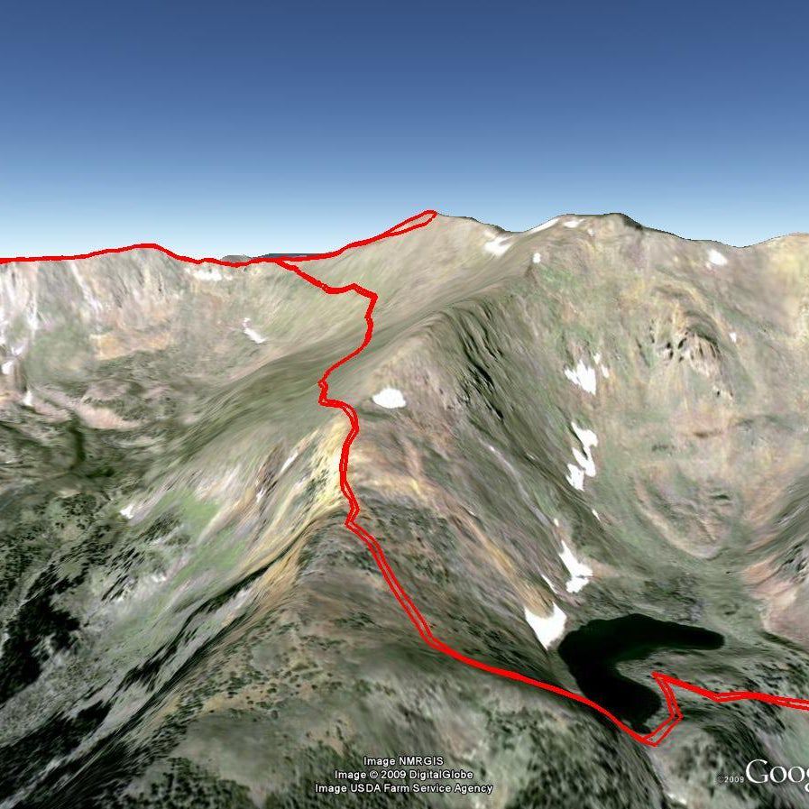
Despite being mere state land, the Revelation Mountains between Lake Clark and Denali National Parks are filled with unnamed peaks far more jagged and glacier-clad than anything in the Sierra or Cascades. The entire range, more than 90 miles long, was largely unknown until the Harvard Mountaineering Club climbed here in 1967. Over the years, we’ve sampled a lot of Alaskan scenery, but for visual impact and exploratory opportunity, the Revelations are second to none.
The loop described here includes rugged trekking, roped scrambles, and swiftwater paddling in small, inflatable packrafts. Some adventurers have done parts of this route, and Sled Pass was used by ancient Athabaskan Indians, but the trip is not for rookies. Despite the efforts of our strong party, the loop remains unfinished.
To be the first to complete it, you’ll need intermediate whitewater paddling skills, as well as climbing and glacier gear, packrafts (alpackaraft.com), collapsible paddles, and inflatable PFDs. There’s at least one deep river ford between dangerous rapids. We recommend going with a guide and allowing 11 to 14 days for the attempt.
Begin from a gravel bar in the narrow gorge of the Stony River’s upper East Fork.
SRL002
Location: 61.3679008483887, -153.646057128906
Continue NE
SRL003
Location: 61.3823165893555, -153.600173950195
Continue NE up steep, narrow valley
SRL004
Location: 61.3948822021484, -153.554489135742
Near mile 5, hug S cliffband
SRL005
Location: 61.3969841003418, -153.552520751953
Good campsite
SRL006
Location: 61.4003562927246, -153.547744750977
Tough river crossing between dangerous rapids
SRL007
Location: 61.4052658081055, -153.551666259766
Begin climbing up a short strech of 5.5 rock slabs
SRL008
Location: 61.4054832458496, -153.552825927734
Top of slabby climb; continue ascent
SRL009
Location: 61.4090003967285, -153.558654785156
Continue N, eventually you’ll ascend a long glacier
SRL010
Location: 61.4161148071289, -153.557983398438
Nice campsite
SRL011
Location: 61.4231643676758, -153.563858032227
Hard, gritty ice en route to the upper East Fork of the Stony River
SRL012
Location: 61.4766426086426, -153.560287475586
Unnamed pass; route drops E
SRL013
Location: 61.4828338623047, -153.54963684082
At mile 12.2, the land eases with flower-filled tundra
SRL014
Location: 61.4891662597656, -153.506454467773
Possible campsite
SRL015
Location: 61.5589828491211, -153.463165283203
Launch on the South Fork of the Kuskokwim’s gravel creekbed for a class II-III whitewater ride into a wide valley.
SRL016
Location: 61.5767822265625, -153.4560546875
Good campsite off the Kuskokwim. EDITOR’S NOTE: Our scouting party was forced to turn-around at this point. The route from here to Waypoint 20 is the route suggested by others who’ve done sections of this loop and bush plane flyovers. Actual track might be slightly different.
SRL017
Location: 61.7346878051758, -153.366470336914
Leave Kuskokwim and hike due west to the Hartman River and ascend its Pass Fork to Sled Pass’s broad tundra saddle.
SRL018
Location: 61.6958122253418, -153.629318237305
Head SE up Pass Fork
SRL019
Location: 61.6436882019043, -153.715057373047
Sled Pass. Drop SSW off the pass, then descend the upper reaches of the main Stony River and relaunch rafts once river conditions allow. Paddle challenging water past the East Fork confluence.
SRL020
Location: 61.3571319580078, -153.722747802734
Confluence. The Stony becomes broad and placid.
SRL021
Location: 61.2722663879394, -153.798446655273
Float past Harrower Lodge, a super remote yet posh retreat for hunters and corporate events.
SRL022
Location: 61.0710334777832, -153.996383666992
Option 1: Bush plane fly-out spot.
SRL023
Location: 61.0744361877441, -154.011184692383
Option 2: Bushplanes fly out of this small lake off the Stony.
*****
Logistics: Fly Lake Clark Air’s regular air taxi from Anchorage to Port Alsworth, then a bush plane to the gravel-bar landing.
Guide Service: Alaska Alpine Adventures: (877) 525-2577; alaskaalpineadventures.com
Contact: Lake Clark Air: (888) 440-2281;