San Diego: San Pasqual-Clevenger Trail South
San Diego: San Pasqual-Clevenger Trail South
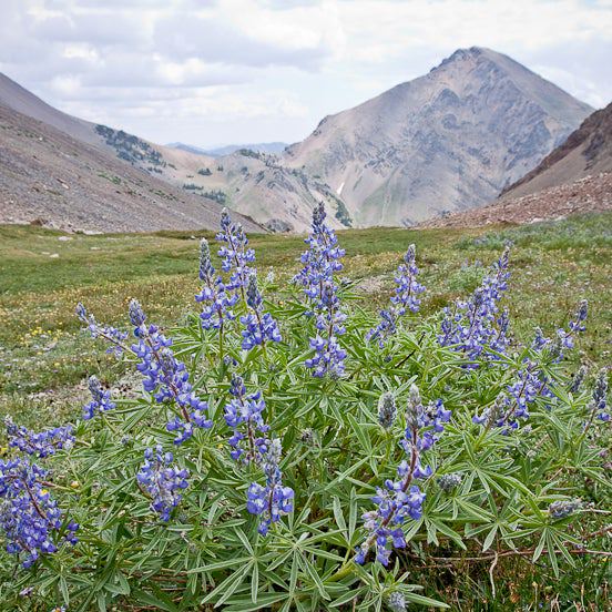
Link two unnamed peaks in the rugged hills above San Pasqual-Clevenger Canyon on this challenging 4-mile, half-day hike.
Heading out the door? Read this article on the new Outside+ app available now on iOS devices for members! Download the app.


Trail Facts
- Distance: 3.2
Waypoints
SPT001
Location: 33.0849189758301, -116.922096252441
Head S from Tim’s Canyon into gentle switchbacks dotted with coastal sage scrub
SPT002
Location: 33.0813407897949, -116.921798706055
L @ Y; reach small ridgeline overlook with impressive views E into the folds of Santa Ysabel Creek, then descend into ravine
SPT003
Location: 33.0793037414551, -116.920829772949
Cross seasonal dry creekbed and pick up rising trail along ridge through low pockets of green deerweed topped with yellow-to-red corolla blooms
SPT004
Location: 33.0770111083984, -116.91739654541
Last 300 ft. of climb gives vantages W to the patchwork farms of San Pasqual and jagged slopes of Clevenger Canyon
SPT005
Location: 33.0757827758789, -116.917015075684
Crest ridge: Take L @ T
SPT006
Location: 33.0764122009277, -116.913917541504
Travel rocky path around first unnamed high point (1,755 ft.); from boulders, it’s a clear view to Mt. Woodson and the uplifted plains of the Santa Maria Valley
SPT007
Location: 33.0780868530273, -116.909843444824
L @ Y, veering N along ridgeline where chaparral thins
SPT008
Location: 33.0822792053223, -116.907997131348
Trail dead-ends @ second unnamed summit with more views into nearby canyons. Retrace route to car
Looking back into the valley
Location: 33.0773010253906, -116.917495727539
©Rajeev Jain
From the second summit
Location: 33.0821838378906, -116.90803527832
The lush river bottom snakes through the foothills. ©Rajeev Jain
Canyons Abound
Location: 33.0790977478027, -116.909439086914
A knobby, canyon-filled landscape can be seen from the saddle between these two unnamed summits.©Rajeev Jain
A view of Mt Woodson looking SW
Location: 33.0764312744141, -116.911827087402
©Rajeev Jain