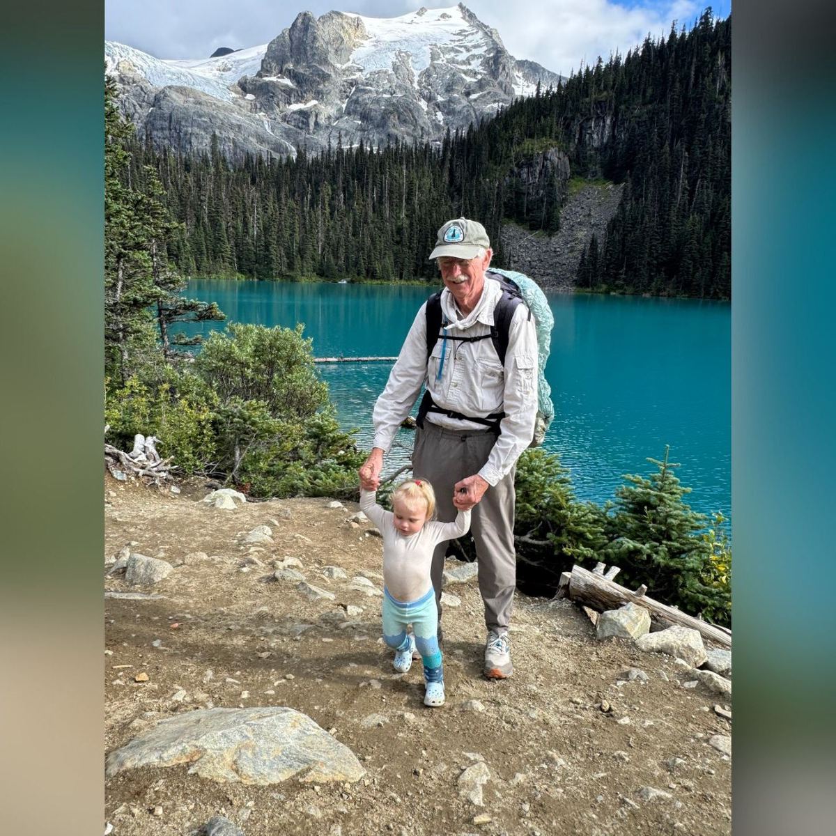
The 10 Best National Parks for Hikers
The 10 Best National Parks for Hikers
Everyone has a favorite national park. But when it comes to hiking, some just do it better than others.
Heading out the door? Read this article on the new Outside+ app available now on iOS devices for members! Download the app.
For over a century, the National Park Service has worked to maintain many of the most drool-worthy trails and landscapes in the United States. As Backpacker editors, we’re well versed in what makes a good trail and national park, but defining one true “best” is a near-impossible task. There are 63 national parks, after all, that vary wildly in terrain and opportunity, so instead of naming one, we decided to get superlative. What’s the best national park for dodging crowds? The best for alpine adventures? The wildest? Check out our picks for the ten best national parks for hikers below.
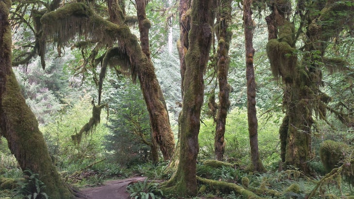
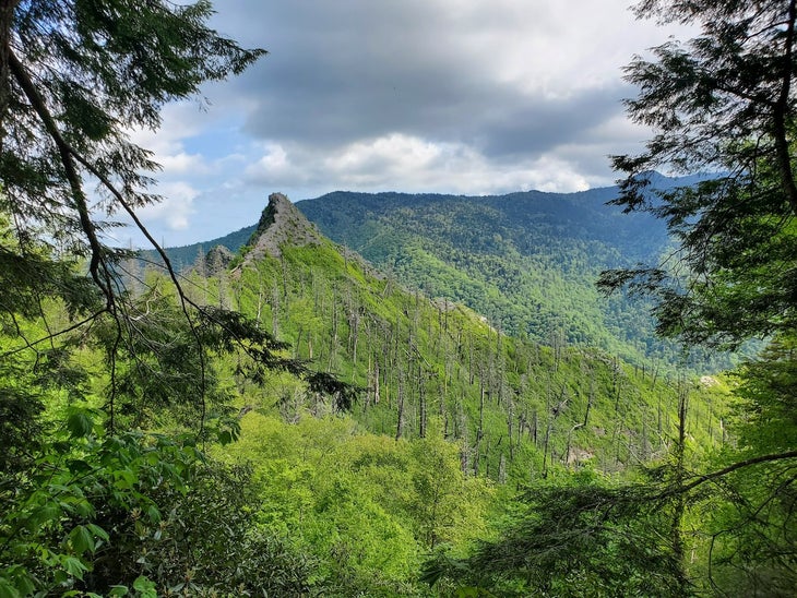
Best Variety: Olympic National Park
At Olympic National Park, hikers are spoiled for choice. On the coast, long beach walks wind past sculpted sea stacks and around tide pools teeming with urchins and sea stars. Some 5,000 feet above that, Hurricane Ridge provides long, alpine rambles and sweeping views of the glaciated Olympic Range. In between those two extremes is some of the thickest, most primeval rainforest of the Pacific Northwest, where ferns grow between moss-furred cedar and Sitka spruce and fat banana slugs slither along nursery logs sprouting chicken-of-the-woods and angel wing mushrooms. With over 600 miles of trail, not even the most determined backpacker could see everything Olympic has to offer in a single trip—but for a park this gorgeous, you’ll want to return anyway.
Hike It: Elwha River Trail
Spend 3 days getting to know Olympic’s deep backcountry on this 45.2-mile out-and-back that takes in the park’s spectacular old growth, glacial rivers, and abundant wildlife. Starting at the Whiskey Bend Trailhead, pick up the Elwha River Trail/Pacific Northwest Trail and follow it through Douglas fir forest alongside the Elwha River, whose milky-blue color derives from the ground-up glacial sediment suspended in it. (Side note: Look for clear-running creeks to fill up your bottle, or else be prepared to endure some premature wear and tear on your filter.) After a night at the Hayes River Guard Station, enjoy another 13-mile out-and-back dayhike along the river before retracing your steps to the trailhead the next day. — Adam Roy, Editor in Chief
Best in the East: Great Smoky Mountains National Park
Solitude can be hard to find in Great Smoky Mountains. This 816-square-mile stretch of parkland on the border of North Carolina and Tennessee is consistently the most popular in the U.S., drawing more than 12 million visitors last year. But get a few miles from the trailhead, and the traffic starts to give way to forested hollows thick with oak and tuliptree, rhododendron-lined paths, and mountain creeks where the park’s more than 30 species of salamander live. A word of caution: Humans aren’t the only ones crowding into this park. Great Smoky Mountains has one of the largest concentrations of black bears in the Lower 48, so you’ll want to make sure you store your food safely.
Hike It: Appalachian Trail
America’s most famous long trail spends 72 miles in Great Smoky Mountains National Park, curving back and forth across the state line as it winds from Fontana Dam to Davenport Gap. Most backpackers will take about a week to travel this slice of hiking history. Along the way, you’ll cross Kuwohi—formerly known as Clingmans Dome until its 2024 name change—the highest point on the trail, and likely rub elbows with thru-hikers traveling the whole damn thing at the park’s 12 AT shelters. (With Great Smoky Mountains National Park and surrounding areas still recovering from Hurricane Helene, make sure to double-check closures on the park’s site.) —AR
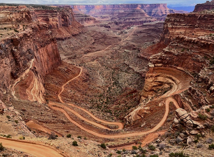
Best for Dodging Crowds: Canyonlands National Park
A hike through Canyonlands National Park is like a tasting menu of the best of southern Utah’s red rock desert. Sculpted sandstone arches and spires overlook mazes of box canyons, and mesa-top trails lead to sweeping views of the Colorado River. And take a tip from a former local: Although it’s far from unknown, Canyonlands tends to dodge the worst of the Moab crowds, who gravitate toward Arches’s frontcountry drives. (Unlike Arches, Canyonlands doesn’t require timed entry reservations.) With hundreds of miles of trail and countless more overland routes possible across its three different units, hikers can find everything from sub-1-mile jaunts to overlooks in Island in the Sky, to challenging, weeklong trips through the remote outback of the Maze.
Hike It: Salt Creek-Lavender Canyon Loop
Experience some two dozen arches, scores of Ancestral Puebloan pictographs, and classic canyon-top views on this 23.4-mile journey in the Needles District that connects the popular Salt Creek Trail to Lavender Canyon via an adventurous overland route. Starting at the Cathedral Butte/Salt Creek Canyon Trailhead, head down Salt Creek Canyon to Big Pocket, a wide-open basin rimmed by sandstone walls, before carefully climbing a series of ramps up to the canyon rim. From there, you’ll need to exercise your routefinding muscles, navigating overland and dropping down into Lavender Canyon before finally connecting the dirt track of Beef Basin Road back to the trailhead. —AR
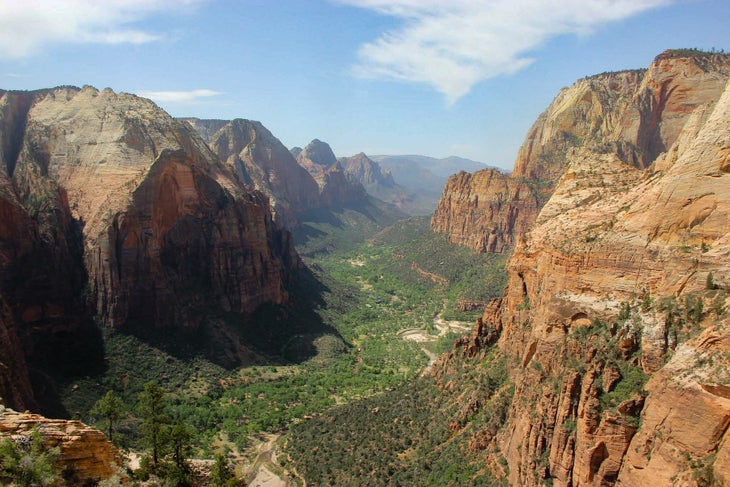
Most Otherworldly: Zion
Hiking in Zion National Park is like stepping foot on Mars—or at least, what we imagine that would be like. From the bottom of winding slot canyons to the top of dizzying precipices, you can take in the desert from every angle. Zion is a great place to hone your canyoneering skills, with non-technical routes like the Narrows, and opportunities to advance to canyons requiring rappelling and navigation skills. The park’s soaring cliffs, scenic rivers, temple-like sandstone formations, and more will make you feel like another planet is around every bend in the canyon wall.
Hike it: The Subway
There are two ways to tackle Zion’s iconic Subway route: bottom-up or top-down. The former is a non-technical out-and-back hike, and the latter requires multiple rappels and mandatory swimming. The 9-mile bottom-up route involves hiking through a rocky streambed, scrambling over boulders, and careful navigation through steep gullies and narrow slots. Intrepid hikers will be rewarded with fun moves over slick rock, waterfalls, potholes filled with emerald water, and the namesake Subway formation—a tubelike tunnel cut into the orange rock by flowing water. Permits are required. —Zoe Gates, Senior Editor
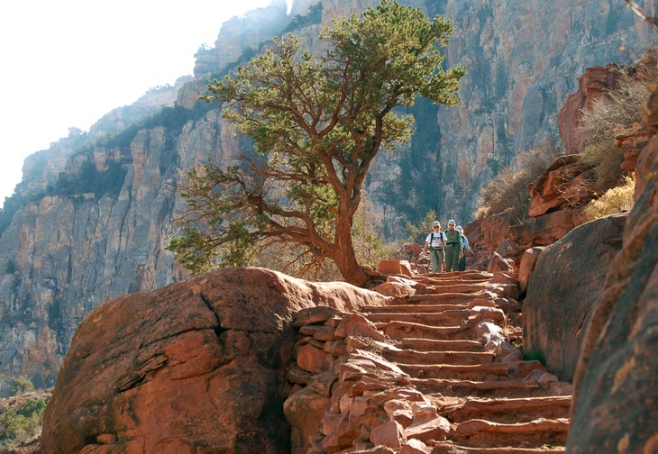
Most Iconic: Grand Canyon
Although best known for its iconic Rim to Rim trek, the hiking opportunities in the Grand Canyon are as endless as the sandstone formations you can take in from the chasm’s edge. My college geology professor used to say that visiting the canyon was like experiencing “the greatest story ever told”: millennia of natural history is visible from every switchback if you know how to look for it. In our opinion, the best way to experience the Grand Canyon is on a float trip down the Colorado River—not for the whitewater, but for the limitless hikes that can’t be accessed from the rim. Scrambling through gorges and creek beds, you may stumble upon petroglyphs, waterfalls, alcoves, and canyon views that will make you feel like the first visitor in a long, long time.
Hike it: Rim to Rim
You can get far off the beaten path in Grand Canyon National Park—but if you don’t have a boat or lots of time, the beaten path itself is pretty spectacular. Crossing from one rim of the canyon to the other allows you to walk through time and experience every rock layer and biome that the canyon has to offer. The 24-mile traverse with over thousands of feet of elevation change is a single-day endurance fest for some strong dayhikers, but also makes a memorable overnight with options to tailor the experience to your preferences. Beginning at the North Rim, hikers can descend toward the Colorado on the North Kaibab trail, switchbacking through geologic wonders. You can camp near the river at the Bright Angel Campground or book a cabin at Phantom Ranch. Or, continue up the other side via the Bright Angel Trail or the South Kaibab Trail—the former is the easier option and popular in hotter weather, and the latter offers sweeping views, but no shade or water. —ZG
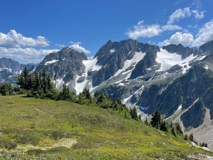
Best for Alpine Adventures: North Cascades
Only one road traverses the entirety of the North Cascades National Park complex, so the best way to see the heart of the park is to lace up your boots. North Cascades is home to more than 300 glaciers, more than 400 miles of official trails, and more than 500 lakes. As you take in alpine splendor from craggy ridgelines or watch mountain goats amble through mountain meadows, you’ll at times feel like you’re in the Alps. But descending into the valleys, as you crane your neck to take in old growth cedars from rainforests bursting with ferns and moss, you’ll have a hiking experience that’s singular to the Pacific Northwest.
Hike it: Cascade Pass and Sahale Arm
Lucky permit winners can spend a night perched amongst some of the tallest towering granite peaks in the park at the Sahale Glacier Camp. But if you’re not fortunate enough to win the permit lottery, the walk to Cascade Pass and up the Sahale Arm is a worthy dayhike. Starting from the Cascade Pass trailhead, hike more than 30 gradual switchbacks through massive trees laden with old man’s beard. Around mile 3, bust out of the trees into an open slope that’s filled with wildflowers and blueberries in summer. Less than a mile more takes you to Cascade Pass, where you can peer into a verdant valley ringed with glaciated peaks. Turn around here, or continue north toward Sahale Arm where you’ll be treated to miles of above-treeline ambling amongst some of the nation’s most scenic mountains. —ZG
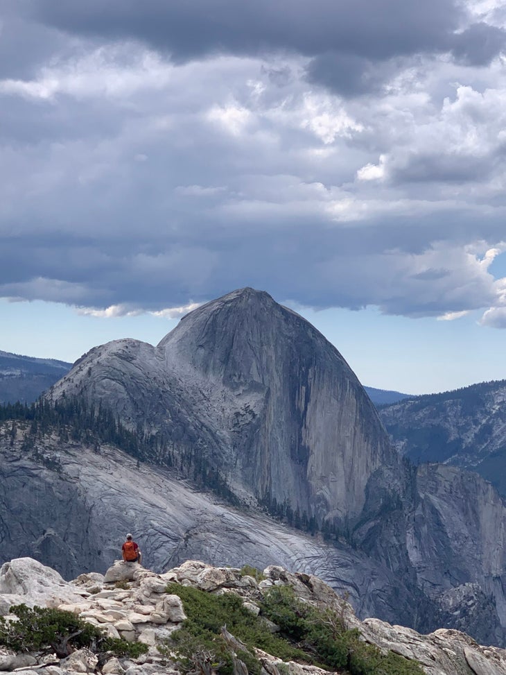
Best for a Classic National Park Experience: Yosemite
It’s hard to think of a national park more classic than Yosemite. Tunnel View—that viewpoint of Half Dome, El Capitan, and other scaling granite walls that Ansel Adams made famous—is one of the most photographed places in the country for a reason. Growing up in Southern California, I spent most summer vacations in Yosemite Valley. Trip after trip, I realized that Yosemite isn’t just a national park; it is the national park. Diverse natural features and an unparalleled density world-class trails spoil hikers here. Within one day, you can see waterfalls taller than skyscrapers, glacier-cut granite walls that inspire hikers and rock climbers alike, and ancient Sequoias that are as big as 30 feet in diameter. Yosemite is my favorite place in the entire world, and I know I’m in good company there. And although the views are great, the trails are even better.
Hike it: Mt. Watkins
Most of the classic hikes in Yosemite—Half Dome, Yosemite Falls, Mist Trail—start in the Valley. That’s not a true representation of all the park’s beauty. Yosemite Valley is only 1 percent of the park’s entire size, anyway. Take a drive on Tioga Road to get a better perspective on the setting John Muir used to convince President Teddy Roosevelt to prioritize conservation. My favorite hike in the park is Mt. Watkins. This trail isn’t as much of a quad-burner as other trails in the Valley can be. There’s no obvious “summit” on Watkins. Just continue down the trail until you reach the smooth granite cliff’s edge for views of Half Dome, Clouds Rest, Yosemite Valley, and North Dome. Most visitors don’t venture beyond the Valley, so you’ll likely have a birds-eye view of the entire park without all of the crowds. Bonus: You won’t have to sacrifice your firstborn for a trailhead parking spot, even in peak summer months. — Emma Veidt, Associate Editor
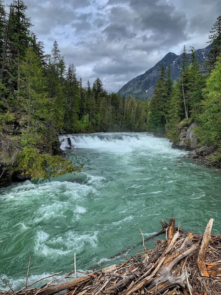
Best Natural Features: Glacier
There is no wrong way to explore the wildest park in the Lower 48. Whether it’s by boat, by foot, or by car, just being able to see the rugged peaks, glaciers, turquoise lakes, or ice-carved valleys is a treat. However, the park itself is so vast that you can’t expect to explore both the east and the west sides on the same day. Heck, even the journey through the park deserves a day for itself: The 51-mile-long Going-to-the-Sun Road was one of the first NPS roads built specifically for tourists in cars. But for wild hikers looking to explore the dense forests and icy streams their own pace, there are 700 miles of gorgeous trails available in the park.
Hike it: Grinnell Glacier
The Kootenai, early Native inhabitants of the location now known to most of us as Glacier National Park, called this area “Ya·qawiswit̓xuki”, meaning “the place where there’s a lot of ice.” That could have been true hundreds of years ago, but today, it can be difficult to see an active glacier within park limits. In 2025, Glacier’s home to 26 glaciers, but that number is down from 150 in 1850. Most of the park’s glaciers are nestling in the Continental Divide, but you can still explore some within reasonable hiking distance. Perhaps the most famous glacier in the park is Grinnell. On the steep 10-mile hike, you’ll also pass waterfalls, lakes, alpine meadows, and maybe a couple grizzlies. (Glacier has a higher density of brown bears than any other national park in the Lower 48.) Not looking to spend all day on the trail? You can trim the hike to 3.5 miles total by taking a boat from Many Glacier Hotel across Swiftcurrent Lake and Lake Josephine. — EV
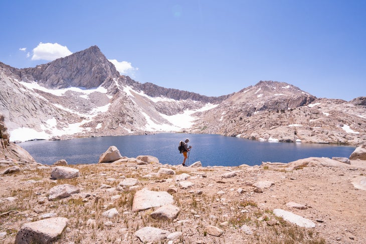
Best For Thru-Hikers: Sequoia & Kings Canyon
Big, tall, and old: Sequoia & Kings Canyon—also called SEKI—boasts a diverse habitat containing some of our country’s most ancient trees and tallest peaks. Sequoia became America’s second national park in 1890, and its goal was to protect the eponymous trees from logging. Today, Sequoia protects the world’s largest tree by volume, General Sherman, which is 275 feet tall and over 36 feet in diameter at its base. When President Roosevelt and Congress established Kings Canyon in 1940, the two neighboring national parks combined to operate under a single administration. Kings Canyon’s glacially carved valleys and towering redwoods (including General Grant, America’s Christmas Tree) plus only-accessible-by-foot views make it one of the best national parks for hikers.
Hike it: High Sierra Trail
SEKI is the park for hikers. It not only intersects with the John Muir Trail and Pacific Crest Trail, but it also is home to its own miniature thru-hike, the High Sierra Trail. Completed in 1932, this 72-mile-long trail is a symbol of the park’s historic support of backcountry trail construction. Start in Crescent Meadow in Sequoia National Park and cross through the Sierra, stopping for a soak in the alpine lakes and hot springs along the way. Reach the finish line at Whitney Portal, but while you’re there, you might as well summit the highest peak in the Lower 48. — EV
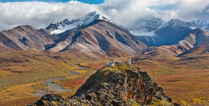
Wildest: Denali
If raw and wild wilderness is what you’re after, you’ll find it—and then some—in Alaska’s iconic national park. From grizzlies and wolves to glacier-melt rivers to the highest peaks in North America, Denali delivers a total immersion in a landscape far different from what most of us are used to. But the scenic highlights are just the start. Denali feels extra wild because there are no trails in the backcountry. Go backpacking here, and you have to be hyper-engaged with the wilderness, navigating the epic terrain without trails or signs or bridges. Sometimes that means traversing open tundra with glorious views of the Alaska Range—just like in the pictures! But sometimes it means bushwhacking through dense willows, fording icy, fast-moving streams, and scrambling steep scree slopes. For hikers who are prepared for the challenges, Denali raises the bar on what it means to do a life-list trek.
Hike it: Expert tips
Planning a backpacking trip in Denali is unlike preparing for other national parks. Not only are there no trails, there are also no reservations. Here’s how it works: The backcountry is divided into units. You need a backcountry permit for specific units, and you can only get the permit at the park, in person, no more than a day before you start hiking. That means you show up and choose units based on what’s available (if none are available, you’ll have to try again the next day). It pays to research various routes and units ahead of time—we love the Thorofare River—so you can choose the best hike for your schedule and experience level, but ultimately you’ll have to adapt to what’s available. — Dennis Lewon, Director of Content
From 2025