The Best Ridges, Peaks, and Lakes on the Continental Divide Trail, According To a Thru-Hiker
The Best Ridges, Peaks, and Lakes on the Continental Divide Trail, According To a Thru-Hiker
Take it from someone who has done it all. Here are the CDT's highlights, in the form of geysers, peaks, and lakes.

Heading out the door? Read this article on the new Outside+ app available now on iOS devices for members! Download the app.
The Continental Divide Trail goes through some of the most wild, beautiful, and remote backcountry the United States has to offer—but few have the time to hike the entire 3,100-mile beast. Luckily, a weeklong or even weekend hike on the Continental Divide can be enough to get a wonderful taste of this national scenic trail that meanders from Mexico to Canada through New Mexico, Colorado, Wyoming, Idaho, and Montana.
As someone who once restructured their life to thru-hike the CDT, I understand the appeal of using just a few PTO days to explore some of the best sections. I also understand the overwhelming feeling of trying to decide where to start. These five Continental Divide Trail hikes stand out in my memory as some of the most enjoyable swaths of trail that hikers could do with a long weekend or less. Note: Official CDT mileage differs slightly depending on the mapping service you’re using.
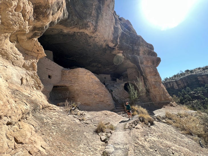
Gila Cliff Dwellings and Jordan Hot Springs, New Mexico
Miles: 13.8 miles (out-and-back, add a 1-mile loop to view Gila Cliff Dwellings National Monument)
Elevation Change: 2,393’ ascent, 2,378’ descent
Days: 1-2
CDT Mile Marker: Gila River High Route Alternate Mile 0.7-3.0 > Little Bear Canyon Alternate (1.9 miles) > Gila River Alternate Mile 48.9-51.6. Bonus: Gila Cliff Dwellings National Monument 1-mile loop.
In true CDT fashion, this first section is actually a combination of official alternates. Most CDT thru-hikers opt for the Gila River alternate over the official trail (and for good reason). The Gila River Canyon is a gorgeous environment unlike any other along the CDT. What you get in views you will pay for in river crossings, but this particular route maximizes beauty and culture while attempting to minimize excessively wet feet.
For an extra dose of history, start your trip with the 1-mile loop around Gila Cliff Dwelling National Monument. Though not an official section of the CDT, or even an official alternate, it is well worth the nearby side trip if you are in the area. After that, start your longer hike from the TJ Corral Trailhead which is on the Gila High Route CDT Alternate. Follow that trail for 2.3 miles until you reach the junction with Little Bear Trail, which will take you through almost 2 miles of winding Little Bear Canyon. At the end of the canyon, you will join the Gila River Alternate. Take a left at the junction and in just under 3 miles, reach Jordan Hot Springs. Relax your tired legs in the edenic oasis and recharge for the hike out or camp nearby.
If you have extra time, continue on past Jordan Hot Springs to enjoy even more of Gila River Canyon’s towering walls and turn around whenever you’ve had your fill.
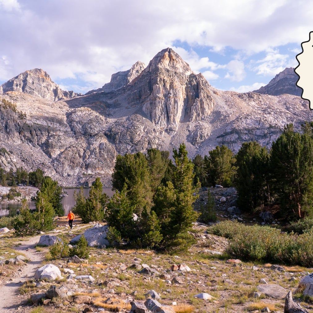
Grays and Torreys Peaks, Colorado
Miles: 17.7 miles (point to point, reduce mileage with 4WD vehicles)
Elevation Change: 5,109’ ascent, 5,794’ descent
Days: 1-2
CDT Mile Marker: 1258.9-1276.6
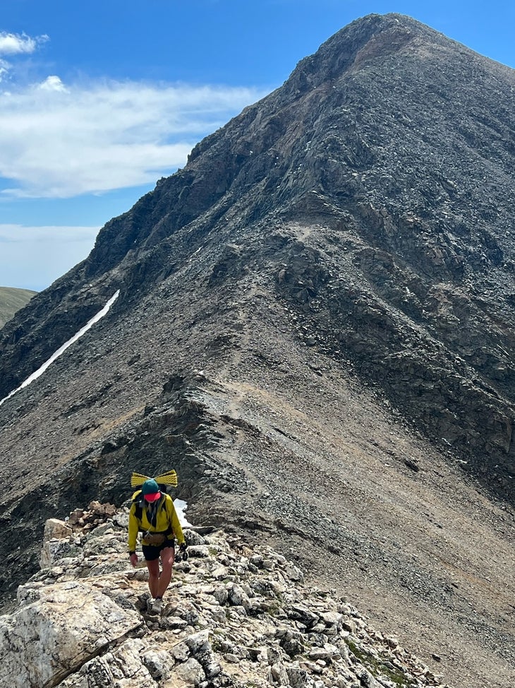
This breathtaking section of the Continental Divide Trail takes you over the trail’s high point, Grays Peak (14,254 ft.). Though not on the official Continental Divide Trail, Torreys (14,275 ft.) shares a saddle with Grays and is only 0.7 miles away from the Grays summit (a worthy sidequest). On your way to Grays, you also summit Mt. Edwards (13,839 ft.). The 1.3-mile section between Mt. Edwards and Grays is a class 2 ridge that I wouldn’t recommend to anyone who shies away from exposure.
Start this day very early and keep a close eye on the weather, as much of the hike is above tree line and will be much slower than your typical hiking pace. The strenuous, exposed terrain pays off with sweeping views of Colorado’s high country. Don’t forget to turn around on your descent into Grays Peak Trailhead as the peaks you’ve successfully put behind you come into full view. If you’re lucky, you might even see a mountain goat or two.
Shuttle cars between the Chihuahua Lake Trailhead and the parking area off I-70 (or Herman Gulch Trailhead). If you have a 4WD vehicle, you may be able to access the 4WD trailheads and cut some mileage off of one or both ends of this hike.
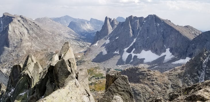
Cirque of the Towers Loop, Wyoming
Miles: 23.8 miles (loop)
Elevation Change: 4,465’ ascent, 4,449’ descent
Days: 2-3
CDT Mile Marker: Cirque of the Towers Alternate Mile 11.4 – 21.5 > CDT Mile 1773.7- 1781.9 (Plus 5.5 miles of Fremont and Big Sandy Trails)
Cirque of the Towers might just be one of the most iconic places on the CDT, despite it technically being an official alternate and not the main trail. This loop will take you along the best parts of the alternate, as well as some official CDT miles. It’s the best of both worlds with one convenient place to park your car.
The Wind River Range is notoriously hard to access. With Big Sandy Trailhead being one of the innermost trailheads in the range, expect a long drive on dirt and washboarded roads (though a 2WD vehicle should be able to handle them just fine). From the trailhead, take Fremont Trail to Big Sandy Trail which will eventually become the official Cirque of the Towers Alternate. Big Sandy Lake is a good campsite for night one that will set you up for a gorgeous day two in the Cirque. From Big Sandy Lake, continue on the Big Sandy Trail over Jackass Pass and around Lonesome Lake, the highlight of this loop and an excellent place to stop for a long lunch. (If you choose to camp in this area, be aware of restrictions as there is no camping within a quarter mile of the lake.)
From Lonesome Lake, hike over the formidable Texas Pass. Once over the pass, you’ll hike past a series of breathtaking alpine lakes. Eventually, you will join the Shadow Lake Trail and follow it until you reach the intersection of Trail 7096, or the official Continental Divide National Scenic Trail. Take it back to the Big Sandy Trail and, eventually, your car.
Shoshone Geyser Basin & Old Faithful Village, Yellowstone National Park, Wyoming
Miles: 26.5 miles (point to point)
Elevation Change: 2,492’ ascent, 2,995’ descent
Days: 2-3
CDT Mile Marker: 1975.8-2002.3
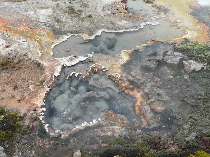
The geothermal activity in this little-trodden stretch of Yellowstone is captivating and sometimes a little unnerving. Start this hike at a parking area just north of the Heart Lake Trailhead on South Entrance Road. (If you have extra time, I recommend a 15-mile out-and-back on the Heart Lake trail to its namesake through Heart Lake Geyser Basin.) From the parking area, take the CDT along the shores of Lewis Lake, eventually paralleling and then crossing the Lewis River at the Shoshone Lake Outlet. After hiking around Shoshone Lake, you will reach Shoshone Geyser Basin. Here, you will be greeted by signs warning you to stay on trail, as wandering off the path could lead to a potentially fatal fall into the area’s many geothermal springs. (Unlike the frontcountry of the park, these geysers will be completely unobstructed by other visitors or park infrastructure. There is one that goes off every 2 or 3 minutes right next to the trail.) Consider taking a long break in this area and soaking in the sulphuric steam of these incredible geological features.
Once through the basin, make your way through some comparatively uninteresting forest before reaching the infamous Old Faithful Village. End your hike here or continue along the boardwalk that is home to many beautiful geysers and springs with ample informational plaques to peruse at your leisure. (Note that the parking lot and boardwalk at Biscuit Basin, located north of Old Faithful, is currently closed following a hydrothermal explosion in July 2024; find updated information on the park’s site.) The further you get from the village on the CDT, the fewer tourists you will encounter. If open, I recommend following the CDT until the parking area on the Firehole River off Grand Loop Road for maximum geothermal sightseeing.
Keep in mind that you need to obtain permits to stay overnight in the park.
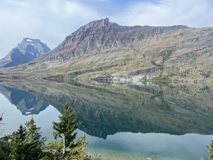
Two Medicine to Saint Mary Lake over Pitamakan and Triple Divide Pass, Glacier National Park, Montana
Miles: 39.3 (point to point)
Elevation Change: 9,468’ ascent, 9,347’ descent
Days: 3-4 days
CDT Mile Marker: 2,906.0-2945.3
It is near impossible to pick just one “must hike” section in Glacier National Park along the CDT, because so much of it is stunning. This almost 40-mile section between Two Medicine and Saint Mary will take you through some incredible highlights, including two passes and some gorgeous waterfalls.
Depart Two Medicine on the Pitamakan Pass Trail and gradually ascend into the alpine, taking in sweeping views of Pitamakan and Oldman Lakes from the eponymous pass. Make your way north on the Continental Divide Trail and eventually ascend Triple Divide Pass. On hiker’s left is Triple Divide Peak, the hydrological apex of the North American continent; depending on which flank of the mountain it falls on, rain from Triple Divide can flow into the Pacific, Atlantic, or Arctic Ocean. During my visit, I saw bighorn sheep on this pass and had elk bugles as the soundtrack to the descent. As you progress, you will cross several of the park’s famous suspension bridges and hike along the shore of Red Eagle Lake, where I awoke to find moose playing in the water.
Eventually, you will reach the shores of the vast Saint Mary Lake. After passing Virginia Falls, you will come to a bridge over Saint Mary Falls. If you’re feeling adventurous, consider washing off the trip’s grime with a cliff jump into the Saint Mary River on the other side of the bridge. You’ll know the right spot when you see it.
Remember, you will need permits for camping in the park. Conveniently, Glacier’s backcountry campsites feature pit toilets and poles to hang your food. Consider looking into the park’s transit options to avoid shuttling cars.
Tips for New Continental Divide Trail Hikers
The Wyoming and Montana sections in this list are in grizzly territory, so please carry bear spray and store your food appropriately if you choose to visit these areas. It’s also worth noting, that due to the nature of the CDT, many of these trailheads are fairly remote. However, they are all accessible by 2WD vehicle. I promise any logistical hurdles involved in reaching these places are worth the trouble.
From 2025