Thru-Hiking Wisconsin’s Ice Age Trail is a Step Back in Time
Thru-Hiking Wisconsin’s Ice Age Trail is a Step Back in Time
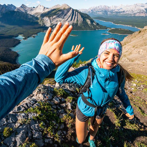
A Triple Crowner discovers how this little-known trail turns the hiking world on its head.

Heading out the door? Read this article on the new Outside+ app available now on iOS devices for members! Download the app.
“Scout, what are you craving?”
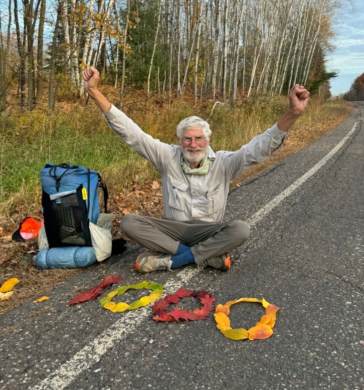
I’d passed 900 miles on the Ice Age Trail. I was three-quarters done. Wisconsin’s dial was set to “dazzle”: Leafy fireworks burst overhead, pyrotechnic yellows, reds, and oranges that would put a Monet canvas to shame.
It was October 17, my 73rd birthday. I would cover 20 miles and probably see no one. A Hostess Cupcake twin-pack was in my backpack, chocolate frosted with a white curlicue on top. Two days before, I bought it at a two-pump gas station in Rib Lake, pop. 902. I’d just wondered, Will it be stale? when that text came in from Crystal Gail Welcome, a thru-hiker who’d stayed with my wife and me in San Diego before she’d started the Pacific Crest Trail in 2016. I hadn’t seen her in eight years, but she had heard I was spending my birthday on the trail, out in Wisconsin’s remote Northwoods.
What are you craving? I texted back: “Hot chocolate and a turkey sandwich.” Only a moment before my trekking pole had broken through pond ice. We agreed to meet at a dirt road I’d cross mid-afternoon. She was well on her way when I learned she was driving six hours to do this. I tried to stop her. She refused. (Crystal, it made my day.)
If this was most any other long trek, I’d be in the midst of a hiker cohort. But on the Ice Age Trail, even this far along, I’d only met 15 backpackers, all fleeting interactions. When Crystal and I lit a hurricane match in my Hostess Cupcake, she’d be the only one I’d interact with for 36 hours.
Do you wish you had hiked the Appalachian Trail in the ‘70s or the Pacific Crest Trail in the ‘80s, back when they were still relatively unknown and you could go days without seeing another soul? You may find exactly that on the Ice Age Trail, an Alice in Wonderland-esque adventure along wooded paths, across bridges and country roads, and through towns with some of the friendliest trail angels and locals you’re ever likely to meet.
Only 11 routes share the Ice Age Trail’s pedigree as a National Scenic Trail. But unlike the Appalachian and Pacific Crest Trails, the Ice Age Trail traverses a single state, not several. Its 1,200 miles follow a winding route across Wisconsin, shoehorned into a state that’s only 260 miles wide. Other trails date back centuries and follow trapper, trader, or indigenous paths. But this trail’s roots go back millennia: The Ice Age Trail follows the furthest reach of the last Ice Age glaciers, which melted 10,000 years ago as the Pleistocene Epoch waned. Blanketed by an ice sheet up to two miles thick, Wisconsin was flattened, the Earth’s crust depressed, so much that the state is still rebounding. Left behind were glacial features with names I’d barely heard before: eskers, drumlins, kames, and kettles.
Day 1: I hadn’t yet hiked 5 miles when I stepped onto my first town sidewalk. Sturgeon Bay could pass for a quaint New England seaport, except it abuts Lake Michigan. Hungry already, I entered the A’Boat Time Café, dropped into a Naugahyde-padded booth, and ordered breakfast. The waitstaff, Lauren and Danielle, chatty and curious, had no idea a 1,200-mile trail was just out their doorstep. “I read the book Wild,” one said. Both chimed in that they wanted to hike, maybe someday. Between forkfuls of pancakes and hashbrowns I offered, “Just get a ride five miles north and walk back to the café.” I finished and the pair waved off my credit card. “It’s our treat.” Lauren and Danielle, I hope “someday” comes soon for you.
Day 13: What happened today felt rarer than winning the Powerball Lottery. I was 240 miles along and not long after lunch I stopped and talked with a couple dayhiking in the rain. They lived nearby, had kids and grandkids like I do, and had even lived for a while in California, 30 minutes north of my home. We hiked on in opposite directions. A moment later I heard a shout. “Scout, would you like to stay at our home tonight?”
Tom and Sue had both walked off thinking the same thing, but first needed to check with each other. I had thought that night would be one of those where I’d have to get creative to camp. Instead, we planned to meet later that afternoon at a nearby trailhead. For the next eight miles, I looked forward to a home-cooked meal and like-minded conversation.
At the trailhead, I removed my mosquito head net and took the front seat in their car. In the backseat Sue was bouncing, antsy. As we drove away she said, “Tom, can we tell him now?”
During the hours we were apart, their mail had arrived with a package. It was from their best friends, a couple from San Diego. Inside the package, on that day of all days, was a book and a letter from Dave and Lori Jones, acquaintances I had not seen for over 20 years. Dave had sent Tom a copy of my book Journeys North.
“Hey Tom, this book was written by a guy we used to play volleyball with in the ‘90s,” Dave’s letter read. “Great guy! A bit of a different way of a take on trail books. But a good read.”
What if I’d taken longer at lunch? What if the rain had cancelled their hike? What possessed Dave and Lori to send a copy of my book now, four years after its publication?
On another trail there wouldn’t have been a reason to worry about “creative camping.” On another trail I would likely have been hiking with others; would Tom and Sue have invited us all into their home?
But I was on the Ice Age Trail.
That night after dinner, Sue and Tom reached out to Dave and Lori on FaceTime. “Thanks for the book. We just got it. Here’s someone who would like to say hello.” When Dave and Lori saw my face, their chins dropped.
I live in San Diego. Why this trail?
In 2020, my latest book, Journeys North, came out and I appeared on several podcasts. When I listened to one, I’d accidentally tuned in to the episode before mine. The guest was Luke Kloberdanz, a 2003 Ice Age Trail thru-hiker, one of the earliest. What Kloberdanz described was different from any other trail I’d hiked. I’ve backpacked 18,000 miles, including the Triple Crown, but I’d never stepped foot in Wisconsin. I’d never eaten a cheese curd, much less one that “squeaked.” I’d never walked a long trail that goes through 60 small towns but could potentially leave me alone for days. His talk of long road walks didn’t discourage me, and his description of the remote Northwoods, of the prairies, and the glacial features whetted my appetite. I was sold.
Back in 2003 when Kloberdanz thru-hiked, he was a young elementary school teacher. Today, he has salt and pepper hair and two boys of his own. He’s traded chalkboards for a desk and a title: Executive Director and CEO of the Ice Age Trail Alliance. Backpacker once labeled this trail “one of the least known National Scenic Trails,” but the Alliance, the supporting non-profit, is one of the more robust organizations in the trail world. Kloberdanz has a staff of over 20 with an annual budget north of three million. The Alliance organizes 100,000 volunteer trail maintenance hours every year, and has a state-wide fourth-grade program, Think Outside, that brings 5,000 students to the trail every year. Its 2024 October Mammoth Challenge—hike 44 miles and visit three trail towns—had 9,000 registrations. For a trail so little used, it is one of the best maintained and signed.
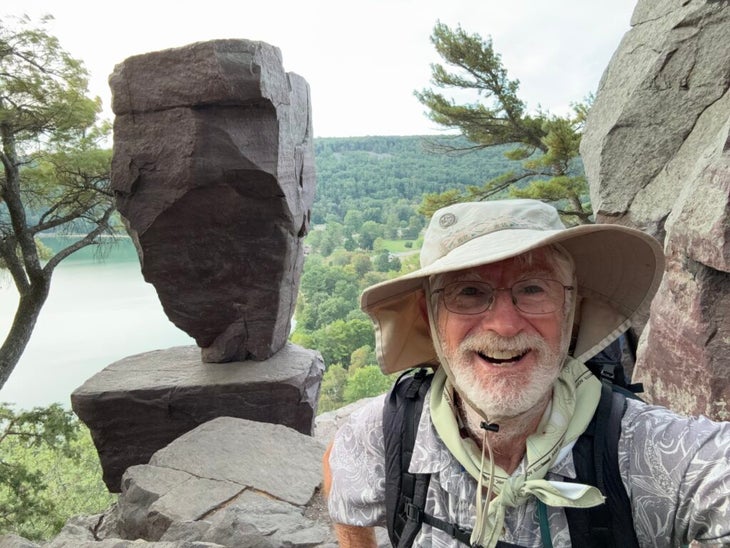
“Do you often meet people who’ve never heard of the trail?” When I asked Kloberdanz or Alliance staff this question, their reaction was to laugh. Kloberdanz said he’d given talks where three-quarters of the audience had never heard of the Ice Age Trail. Melissa Pierick, the Alliance’s Communication and Marketing Director, put it charitably: “That’s true, but it’s becoming less so.” Mike Wollmer led the Alliance for 15 years immediately before Kloberdanz. His answer referenced popular Devil’s Lake State Park, where the IAT’s distinctive yellow blazes mark out a dozen miles of the trail.“Three million people visit and hike there every year, but the vast majority have no idea they are on a 1,200-mile track,” Wollmer said. “They think they are on a local trail.”
Each of these three, Kloberdanz, Pierick, and Wollmer, put me up in their homes overnight.
Day 22: During the 66 days of my thru-hike I saw 19 other backpackers. None were hiking my way, east-to-west. If you want company—except for the well-traveled town segments—you better arrange it yourself.
Eric Guehna was my third thru-hiker. I’d hiked 360 miles and he was nearing his homestretch. The section of trail we were hiking ran on the bed of an abandoned railroad. Guehna and I saw each other from so far away that I wanted to run toward him with arms outstretched like in an old movie. We sat in the middle of the wide path and swapped stories like baseball trading cards.
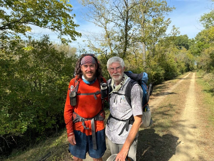
Ahead of Guehna were 60 miles in the Kettle Moraine State Forests. I didn’t attempt to do justice to that overhanging oak savannah, to miles through stands of white-barked birch and sugar maple breaking out in fire-engine reds. Except for mentioning mud, he didn’t paint a picture of the Northwoods that would dominate the last third of my hike—the resurgent beaver ponds, the flocks of wild turkeys. Beavers were once nearly extinct in Wisconsin, and before 1976, when Wisconsin’s department of Natural Resources released 29 Missouri turkeys, history books stated that the last wild turkey sighting was in 1881. Guehna and I had one last laugh when he told me he’d named his shoes Forrest and Jenny, from the book Forrest Gump. Our inevitable goodbye felt poignant; on other trails, I’d meet the same thru-hikers again and again. But on the IAT, I knew I’d never see Guehna again. Too soon we headed our opposite ways.
I wish we were around a campfire so I could wax on about the people I met as the embers burned low. You’d hear about Serena Stipek, a section hiker who grew up in Cornell going on school hikes on a local path marked with yellow blazes called the Ice Age Trail. Decades later she was surprised to see the same blazes and trail name a hundred miles away. Eighteen months later Stipek had section hiked the entire trail, and on two different days last fall we met on trail, traveling opposite ways, of course. Then there’s Pat and Julie Kosher who let me take over their basement for a few days, long enough for their grandkids to expect me on the Koshers’ nightly 7:00 pm video call.
Mike Passo took me to his childhood-fave supper club for the best chicken pot pie ever. Gail put me up. Buzz shuttled me. Jared brought me a picnic. I can no more do justice to them all than I can to the Kettle Moraine Forest or to the Northwoods.
I hope Lauren and Danielle actually do get on trail. When they do, I guarantee that their own Tom and Sue, their own Buzz and Jared, await them, just as they await all of you.
What’s so different about the Ice Age Trail anyway?
The Plus Column
Bridges: There are scores, often with city-park-like handrails. In this river-veined state, the whole trail has only four wet-foot fords. “I must be lost,” I thought when I stared down at one. “Where’s the bridge?”
Boardwalks: I’d still be scraping mud off my shoes but for the thousands of feet of boardwalks. Many have handrails, some even benches. Where can I submit my nomination for “Best Maintained Trail?”
Towns: There are 60, all friendly in that genuine, Midwestern way. Need I say more?
Bar and grills: This headline comes from the Minnesota Twin Cities Pioneer Press: “Wisconsin: Where Bars Outnumber Grocery Stores Almost Three to One.” It took a week to realize that any road junction or small-dot village might harbor a bar and grill. My prime navigation aids, the Ice Age Trail Alliance Atlas maps and FarOut app, were of little help, but drilling down in Google Maps I’d strike pay dirt. Food, water resupply, and a Pepsi. Wisconsin has 145 Starbucks, 235 MacDonald’s and 2,732 bars and grills.
Trail angels: I found a trail angel network that compares to or exceeds that of the best-known trails. There is a 20-page list; just ask the Alliance. At first I felt sheepish calling a local chapter coordinator, but I soon realized how thirsty they were to help. I made a photo collage of all who’d shuttled, fed me or put me up overnight. There were 39 smiling faces.
No climbs. That is an exaggeration. But the state’s low point is 580 feet on the Lake Michigan shore, and the high point is the 1,951-foot Timm’s Hill. I recall only a few climbs approaching a 500-foot gain.
Benches: I lost count. My best estimate is that there are 900 to 1,000 trailside wood benches.
The Minus Column
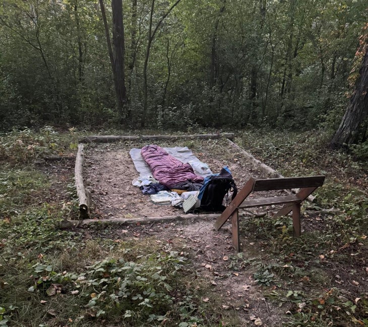
Camping: It’s a challenge. One night the FarOut app reported the nearest campsites were 84.9 miles ahead and 30.4 miles behind. I certainly applaud the Alliance’s growing network of 31 small Dispersed Camping Areas (“DCAs”), but even including public and private parks, trail angel homes, and small town motels, a backpacker still needs to get creative, such as asking permission to camp at a farmhouse, bar and grill, or church.
Road walks: The Alliance divides the trail into 124 trail segments and 76 connecting routes. I passed through cathedral-like forests and expansive prairies, but that doesn’t change the fact that today there are 702 miles of actual trail and 500 miles of road walks. They provided an intimate glimpse into small farm and town life, and an exposure to more fields of corn than I knew existed. It’s rough on the ankles, and it’s an acquired taste.
Water: For a waterlogged state, I rarely used the ground water. So much passes through intensely-used agricultural land. I can’t filter out chemicals and pesticides. I filled up at county parks, restaurants, trail angel homes, farmhouses, and at a remote church.
Views: Simply put, lower your expectations. With limited views, relish forest, prairie, and road horizon vistas. There are a few views worth writing home about, though: Gibraltar Rock, either side of Devil’s Lake, the Lapham Peak Tower, and from the trailside Chippawa Ice Age Interpretive Center.
Getting lost: Beware of a trail prank. Like a card shark it lulls you, dropping onto a wide snowmobile, horse, or bike path and as you enjoy the stroll the trail makes a sharp right or left turn. It only takes a faded yellow blaze or overgrown sign and the next thing you know you’re a hundred yards or more off trail.